Your page to learn about what is happening at City Council related to creating safe and accessible streets in Summerside and Area.  We recognize the focus will be on the City of Summerside; however, if any members have information on the neighbouring communities, please let us know. We will also include related Provincial news as well.

A description of each issue is provided in the table below:

Related Items to SAFE that Required a Council Vote / Motion

Elected Official Emerg Men's Shelter
Nov 21
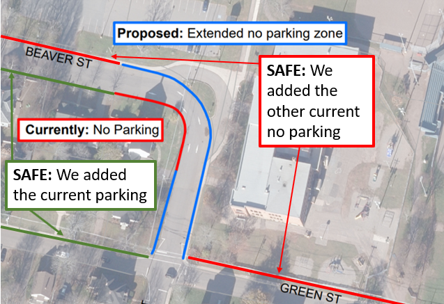
Parkside No Parking
Feb 21
SAFE's AT Network Plan
Apr 4
Pride Week
July 17
Mayor Kutcher (Dec 2022 -) NA NR NR NR
Councillor MacDougall (*1994-) Yes Yes Yes Yes
Councillor Doiron (Dec 2018 -) COI Yes Yes Yes
Councillor/DM Snow (Dec 2018 -) Yes Yes Yes Yes
Councillor Gallant (Dec 2022-) NA Yes Yes Yes
Councillor Cameron (Jun 2023-) NA NA NA Yes
Councillor McColeman (2002 - 2010; 2014-) No Yes Yes No
Councillor Morrison (Dec 2022-) NA Yes Yes Yes
Councillor Adams (Dec 2018 -) Yes Yes Yes Yes
Councillor Ramsay (Dec 2018- 2023) Yes Yes PEI PEI

 * was elected to the St. Eleanors Community Council in 1989
COI = conflict of interest
NA = not appropriate as not sworn in at that time 
PEI = elected District 22 MLA (byelection needing to be held)
NR = not required (a Mayor only votes when there is a tie)

Yes November 21, 2022: Emergency Men's Shelter
Related Story Links: CBC & Saltwire Media
Additional Info: Council Meeting Information Package & Council Meeting Video 

SAFE Summerside supports an emergency shelter for both men and women in the City of Summerside.  On November 21, City Council voted 6-1 in favour and approved a men's shelter in Summerside.  Councillor Doiron removed himself from the vote based on what he deemed a potential conflict of interest.  He has stated he was/is 100% in support.  Councillor McColeman was the lone Council Member who voted against approving an emergency men's shelter in Summerside. This would be the final City Council meeting before the new Council would be sworn in on December 5, 2022.  With the increasing need to support people who need a safe place during the cold months, Council did not wait to vote until the next Council Meeting but acted immediately.


December 19, 2022: Council Meeting

Additional Info: Council Meeting Information Package & Council Meeting Video 

Finance Report (Councillor MacDougall)

  • City departments have submitted capital and operating budgets for the 2023-24 fiscal year.  The administration will review these budgets, and a draft budget will be presented to the council in early February with the goal of presenting this budget in early March 2023.
  • [SAFE Notes] There is still time for the city to consider our proposed new $10M in AT development for a $2M cost. 

Technical Services Report (Councillor Doiron)

  • The active transportation trail is complete, finishing up the final stretch from McLeod St. to Water Street. 
  • [SAFE Notes) New housing units reported on Simmons Ave (60 units) and Water Street East (27 units) would be on the proposed SAFE AT Network route. In addition, the housing units recently announced on Lefurgey (39 senior and 31 family) would also be on our proposed Network. No better time to build AT infrastructure now.

Police Services Report (Councillor Ramsay)

  • Implementing a two-person traffic section to focus on school zones, crosswalks, speeding, etc. Councillor Ramsay: "We have had so many complaints for traffic and safety" (@ 18m:40s)" 
  • [SAFE notes] No longer are the number of calls responded to included in the monthly report.

Municipal Services Report (Councillor Gallant)

  • The new sidewalk machine purchased this year is a great upgrade to reliable sidewalk clearing.
  • The renewable energy being supplied to Summerside surpassed 60 percent the last month, thanks to a windy month.
  • Boardwalk lighting repairs were completed;
  • Pedestrian crossing signals at Small Ave and Water Street were repaired.
  • Approx 100 old power line poles are to be removed because they are no longer in use and/or are in the right of way.
  • Councillor MacDougall (@ 31m:30s) said he would like to see the plowing of the Boardwalk be completed in conjunction with the plowing of the sidewalks and not a day or two days after the street sidewalks have been cleared.   Councillor Gallant reported this was a discussion today, and they are working on that issue.


 PEI Flag Provincial News: December 21, 2022 - End of Fossil Fuel-Powered Sales on PEI by 2035?

The Guardian reports PC Sidney MacEwen's private member's bill, if passed, would set 2035 as the year in which all car sales in the province would be electric-powered.  This would aid in the PEI government reaching its climate goal of net zero emissions by 2040. This bill to be debated in the Spring sitting.


 Canada Flag National News: December 30, 2022 - Canada Sets 100% of new cars sold in Canada to be Zero-Emission by 2035

20% by 2026, 60% by 2030, and 100% by 2035. (The Chronicle Herald, Dec 30, 2022, Page B3)


January 10, 2023  Committee of the Whole

Additional Info: Information Package & Meeting Video [ Minutes ]

RE: East-West Connector (Aaron MacDonald, Director of Technical Services):

[the 25:45 to 56 mins mark in meeting]

    • 2.2 km, 350 acres to develop; will increase revenue via tax dollars 
    • the need for this connector is based on a 2003 or 2004 study

    • [SAFE notes] We looked at the most recent Summerside Traffic Counts to detail the traffic movement.  Note, the table below is based on the excel document, not the online table, as the traffic counts are different, and we would expect the excel spreadsheet to be more accurate):
       Street 2014 2015 2016 2017 2018 2019 2020 2021 2022
      Water Street (Rt 1 to Small) West NA 9,687 NA 11,411 NA 10,201 NA NA NA
      Water Street (Small to MacEwen) West 13,020 NA 12,241 NA 12,937  NA NA 6,831 NA
      Water Street (MacEwen to Harvard) West NA 10,579  NA 9,257  NA 7,524  6,965 6,813 NA
      Glover Shore (Water to End) South NA NA 273 NA NA NA NA 209 NA
      MacEwen Road (Water to Victoria)  7.365 NA 8,130 8,770 NA NA 4,652 5,056 NA
      MacEwen Road (Victoria to Ryan) North NA 5,384 NA 6,585 NA 4,541 3,842 NA NA
      * traffic is counted for a continuous 48-hour period (NOTE: recent traffic counts are lower across the board during the COVID-19 pandemic)

    • To begin, Water Street, MacEwen, and the new East-West connector (all high-traffic streets) require a protected AT Pathway.

    • In 2021 (a COVID year), the only year in which both Water Street (Small to MacEwen and MacEwen to Harvard) data exists, we see an 18-vehicle difference.  

RE: Ditch Infilling (Aaron MacDonald, Director of Technical Services)

The Ditch Infilling Spreadsheet helps to understand the scope of this project.  In total, the R1 properties left to ditch infill are in the 16.5 km range with a cost of $3,024 per metre (according to the online data).  

Deputy Mayor Cory Snow:

  • "I do think there are better areas within our city [to spend the money which] . . . would rather have parks, splash pads, sidewalks, active transportation, transit [than to put the city's dollars on ditch infilling]."  [begins at 2:41:00 mark of meeting)

Mayor Dan Kutcher:

  • "how our streets are designed, I really hope, as we engage the discussions in our official plan we look at street design as a whole.  In a lot of the areas, where there are ditches, there are no sidewalks, and there are no active transportation lanes or networks.  We have an aging community that needs to get out and be active and be able to move in and about their neighbourhoods . . . we need people out, and meeting each other and getting physical exercise and . . . moving themselves around the community in different ways.  When we design streets without sidewalks or without ways for people to move in a safe manner, we run into situations that are certainly dangerous." [begins at 2:56:14 mark of meeting]


January 16, 2023: Council Meeting
Additional Info: Information Package & Meeting Video  [ Minutes ]

 
Finance Report (Councillor MacDougall)

  • We expect to present this budget on Thurs March 9 at 12:00pm and vote on the budget on Wed March 29 at 12:00pm.
  • Preliminary financial results for our fiscal year ending March 31, 2023, are projecting a small consolidated surplus of approximately $53,000; this compares to our budgeted surplus of $6,746. We continue to review our projections with the individual departments.

Technical Services Report (Councillor Doiron)

  • It was a very busy year, but the actual total permit value was considerably lowered than our record of $74 M from last year, but $47M was still way above our previous yearly average of around $27 M / year. I mentioned last year that we had topped $40 M, just 4 times in the previous 15 years, so this year’s total of $47M is another one of those $40 M plus years. It is a great sign of the growth in our City.

Both Councillor MacDougall and Councillor Ramsay stated concerns about the street lights being turned off on the Boardwalk from Northumberland Street to MacKenzie Drive (47:30)


February 7,  2023: Committee of the Whole
Additional Info: Information Package & Meeting Video [ Minutes ]

 
Parkside Elementary Traffic Concern
Purpose: Improve traffic flow and provide safety to students at Parkside School

  • Discussed that PSB, Principal, and others talked with City Staff re: student safety at drop off and pick up time.  Concern for the safety of the children.  The CAO reported this has been an ongoing issue for the school, as other Councils agreed.  The recommendation of those during that meeting was to remove motor vehicle parking on Beaver Street in front of Parkside (on both sides of the streets), see the image below:
    Parkside Recommendation
  • There were some discussions about the potential to turn this small section of Beaver Street into a one-way street (thus, reducing the opportunity for traffic on both sides to drop off children, which happens currently).  It was said to begin with the no parking as recommended and then to see if that helps. There was also the fact presented that buses do turn into Beaver street (heading east) in order to drop students off at SIS.
  • [SAFE notes] This location is a part of our All Ages and All Abilities Network Plan, and we provide this illustration of the this section has been identified as a safety concern for us as well.  Creating an AT Network  "Three School Approach" (Elm Street, SIS, and Parkside) by providing safety for children to walk or wheel to school.  According to pedestrian/cyclist collision data with motor vehicles, 12% of all collisions in Summerside involve the walking/AT routes to these three schools.  We are proposing a new AT Pathway on Beaver Street (Duke to Central) and an improvement of the current sidewalk with a shared AT pathway on Willow (Greenwood to Elm) Beaver (Central to Green) and Green (Summer to Arcona).  We also see Perry Street leaving as is, but safe routes to school designation.  We would also propose yellow flashing pedestrian crosswalk lights at Granville/Green and Central/Beaver.   Here is a map to best illustrate our proposal:
    • Three Schools Safey Connector

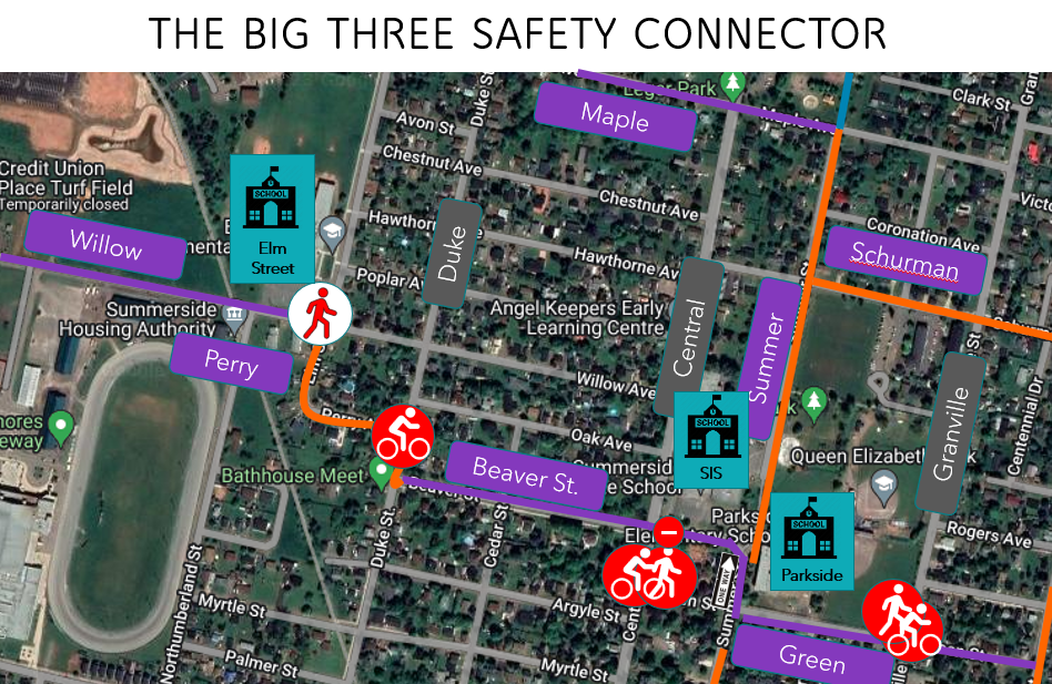
2019-Present: Cyclist Collisions (50%); Pedestrian Collisions (50%); One Pedestrian Fatality, 2020

Please note the above Big Three School Safety Connector was communicated to both the CAO and Mayor on February 15, 2023.


Ditch Committee

  • Mayor announced the development of an Ad Hoc Committee made up of Councillors Snow and Doiron, who would accept written submissions.  They would present the findings/recommendations of the Committee on May 2nd and vote on this issue during the May Council Meeting.  The appointment of Councillors Snow and Doiron to this Committee will occur at the next Council Meeting.


February 21,  2023: Council Meeting
Additional Info: Information Package & Meeting Video [ Minutes ]

 
RESOLUTIONS 
Be it resolved that Appendix A – No Parking Zones of the City of Summerside Traffic and Parking Bylaw CS-27 be amended to include no parking or stopping on the east and west side of Summer Street from Green Street north to Parkside School and around the corner to Beaver Street from Monday to Friday, September to June from 8:00 am to 4:00 pm

Moved by Councillor Ramsay, Seconded by Councillor McColeman.  The resolution was carried unanimously.


APPOINTMENT TO COMMITTEES
Councillors Snow and Doiron were appointed to the "Ditch Committee".

REPORTS

Finance Report (Councillor MacDougall)

  • We are projecting to report a consolidated surplus of $7,403 for the 2022-23 fiscal year and do not anticipate any significant variances prior to March 31, 2023.
  • The preparation of our 2023-24 capital and operating budgets is well underway. We have been deliberating on the 2023-24 budget and will be presenting this budget to businesses and residents on Monday, March 13th at 12:00 pm. Council will vote on the budget at a meeting scheduled for Wednesday, March 29th, at 12:00 pm. 

Technical Services Report (Councillor Doiron)

  • Preparations for the 2023 construction season have begun. Staff is continuing in the process of preparing budgets for the 2023 capital projects. Staff have started the preliminary stages of designing and preparing some tenders for this upcoming season. This work will continue over the next couple of months. It is anticipated that the first few tenders will go out in late March, early April, to be ready for May construction starts.

Police Services (Councillor Ramsay)

  • The new [SAFE added: two-person] traffic section is now fully functioning, and we have seen a substantial increase in traffic enforcement for the month, with 176 charges and 69 warnings issued. This is an increase of more than 100 % from the previous month

Of interest, in January:

Plowing streets 15 times, Plowing sidewalks 13 times, Salt streets 27 times,
Salt sidewalks 24 times, Downtown cleaning 3 times, Parking lot salting 27 times,
Parking lot plowing 15 times, Sidewalk cores 4 times, Hydrant cleaning 1 time.


March 7,  2023: Committee of the Whole
Additional Info: Information Package & Meeting Video [ Minutes ]

 
Ongoing Nuisance, Criminal and Illegal Drug Activity (Councillor Adams)


March 13,  2023: Budget Speech
Additional Info:  Budget 2023-24 & Meeting Video [ Minutes ]


Capital Projects include:

  • $5.5M for the first phase of the east-west connector (which includes Active Transportation)
  • $3.95M to develop the first project at the Summerside Business Commons ($1.5M other gov't sources)
  • $755,000 for street resurfacing
  • $602,000 for remediation of storm sewer
  • $600,000 for a new fire hall
  • $460,000 for downtown infrastructure
  • $385,000 for active transportation infrastructure ("These funds will focus on remediation work to our Boardwalk path, the most significant active transportation corridor in the City that is now connected to our new Greenwood Drive path.", p.7)
  • $271,000 for the replacement of sidewalk
  • $193,500 for ditch infilling program 

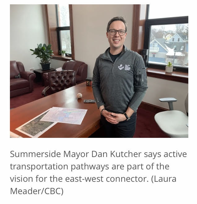
As noted in the CBC article, the new east-west connector will include active transportation. Obviously, incorporating active transportation in the planning stages of new development is best practice and a more cost-effective option than adding AT after construction has been completed.  "You don't have to be taking the car,' Mayor Kutcher said in the article. "We're hoping this will be able to help people walk or take their bicycle."  [SAFE notes]  This will be the first street in the history of the City where active transportation is created in conjunction with a new street.  In our minds, that should have been the "title" of the article: "Summerside Makes History-First Street to be Built Inunison With Active Transportation In Mind!  Kodus for such thoughtful and future-leading commitments.Mayor Dan Kutcher reports new east west connector will include activ transportation


March 20,  2023: Council Meeting
Additional Info: Information Package & Meeting Video [ Minutes ]

 
SAFE Summerside Alliance Presentation to City Council 
This was a big day for our organization.  We presented to City Council a 14 min video, 71 slides of potential questions, a 100-page All Ages & All Abilities Active Transportation Network Plan and the Cycling Without Age Program.  After Council asked their questions, the entire presentation was close to one hour.  We sincerely thank the Mayor and Council for providing us with this opportunity.

Here is our presentation and question period: 


Some key quotes:

Counillor Justin Doiron"I think a lot of the leg work has been done for us. . . I think, quite realistically, you likely saved the City thousands and thousands of dollars that we would have had to put into studies [etc.].  The work that has been done is phenomenal, and I hope we can work towards adopting this, or part of this, or all of this, as an AT policy for the City . . . you have my support." 
Councillor Doiron 


Deputy Mayor Snow"I want to commend your tenacity on this . . . everything you have presented to Council shows the amount of time and effort you put into it.  Regardless of where Council decides to go with active transportation moving forward, I personally do support [active transportation]., "
Deputy Mayor Snow 


Mayor Dan Kutcher"It is very unusual where you get handed a plan of this quality and magnitude. . . It is well thought out, well positioned, and considerate.  It highlights . . .how important active transportation can be for the health of individuals from age 8 to 80, the planet, and the environment.  How active transportation can build more equitable and inclusive communities . . . really showcasing what communities are all about. . . . I will certainly encourage Council to work hard at [moving an active transportation plan beyond the draft stage], and I've said this many times, I think this is really important for the future of our community, For those who need to get out and exercise and socialize, there are real benefits both in body and in mind, but also an important retention and attraction tool for young families . . .  I'm optimistic and thankful, and I think I speak for all of Council here tonight. Thankful for your presentation and everyone behind you, and I know there is a whole bunch of people behind them.  This takes a real group effort, and we can consider the plan submitted at this stage so we can get it to staff and I would encourage any member of the Council to bring it forward at the next Committee of the Whole Meeting . . .  You've presented a really viable framework with a long-term action plan."
Mayor Dan Kutcher 

The outcome: If Council wished to proceed, they will bring this issue to the Committee of the Whole Agenda (the next meeting is in two weeks), and at such time Council may make a request to the City Staff to work towards an Official AT Network Plan. 

REPORTS

Finance Report (Councillor MacDougall)

  • The City delivered its 2023-24 budget to the public on March 13th, and council will be voting on it Wednesday, March 29 at 12:00pm.
  • Highlights from this budget are:
    •  $64.0 million dollar budget made up of $29.8 million for the General Fund and $34.2 million for the Utilities
    • A capital budget totaling $38.5 million with $24 million being the City’s share. Check out the March 13 notes on this page for a look at some of the capital projects.
    • Balanced budget with a small surplus of $4,070 ($3,251 for the General Fund and $819 for the Utilities)


April 4,  2023: Committee of the Whole
Additional Info: Information Package & Meeting Video [ Minutes ]


SAFE Summerside Alliance Active Transportation Network Plan
 
Councillor Justin Doiron requested that active transportation be placed on the Agenda for this meeting.  The meeting opens with Councillor Doiron stating:

Counillor Justin Doiron"I was really looking forward to addressing all of you [SAFE Summerside members in attendance] so I am sorry I could not be there [Councillor Doiron was sick at home].  A few nights ago, Ken Trenholm gave a presentation on behalf of SAFE and I was thoroughly impressed with the depth of that presentation.  I said it then, and I'll say it now, I think that if Council is at all interested in pursuing an AT Plan for the City . . .  I really think we've been handed a plan potentially worth tens of thousands of dollars.  Will there need to be amendments made by staff to really make this work?  Maybe, but maybe not, I think the foundation has been laid and this just makes sense. . . I think we can pioneer this as a City. We've pioneered so many other initiatives.  So much work has been done for us up to this point, and I think we owe it to the incredible number of residents, supporters, and organizations of this initiative to get the ball rolling.  So, with Council's support, I like to ask Staff to begin the steps of adopting and implementing this plan." 
Councillor Doiron 

Here is the response by the City Council as each Councillor presented their views on the All Ages & All Abilities Active Transportation Network Plan for the City of Summerside: 


In the words of the Councillors:

Deputy Mayor Snow"I have no issue with this going forward to Staff for review and recommendations and make sure if there are any issues within the Plan that do not fit with the municipality.  To your point, there has been a ton of work done by Ken and his group, so there is definately value in exploring the plan further.  Taking a reall deep dive into everything in there. . . I think it would be a wise decision to utilize that Plan the way it sits now and see how far we can move it down the line."
Deputy Mayor Snow 


Councillor Rick Morrison"I think it is a great idea that we continue to look at this and work on it and try to bring it to fruition. . . .     And, it may not all happen, but at least, it should be looked at.  It would be terrible if it just sat on the shelf somewhere collecting dust. It is very important.  Health care is the biggest issue we have right now and this is just another step towards helping people be healthy, and setting up your City as a place people want to be active in, and come to.  So, I agree, it is a great thing, and whatever we can do to help, we should be doing."
Councillor Rick Morrison

Councillor Barb Gallant"I want to thank Ken for putting this together.  I am 100% behind whatever Staff can do to pull this together. This is going to affect people from 8 to 80. So, good job."
Councillor Barb Gallant


Councillor Bruce MacDougall"I listened to Ken's presentation and thought it was great.  I would have no probelm with Council accepting the report and sending it off to Technical Services for review and recommendations.  I think it is a great start."
Councillor Bruce MacDougall


"Councillor Norma McColemanI do think you put a phenomenal presentation together that will be really helpful for Council.  It is an important one that leads to activity and socialization for all ages, health, all of those things. . . . I know Councillor Doiron has indicated that possibly the City could pioneer as the City a municipal plan, and I think that sounds really good.  The only thing that I caution us on . . . is how many people would be from the municipality of Summerside because eventually if it was something the City pioneers it is going to come on to our taxpayers. . . I think it is an excellent program and hopefully we can see a partnership moving together."
Councillor Normal McColeman


Councillor Carrie Adams"The information and the time it took to compile that report, it was something else.  And it was very well received.  It was something you could understand.  You didn't have to try to dissect it.  It was very easy and visual.  That helps.  But I did want to ask as on the weekend I noticed there is a house accepting bikes for SAFE Summerside [conversation then on our Bicycle Recycle Program headed by Peter Collins of Rideout's Bicycle Repair in Ellerslie].  "
Councillor Carrie Adams


Motion As Presented by Mayor Dan Kutcher:

Mayor Dan Kutcher"To accept the report as presented by Ken Trenholm and SAFE Summerside and to direct the CAO to work with Ken Trenholm and SAFE Summerside to bring forward an Official Active Transportation Network Plan for the City of Summerside for Council's review, consideration, and potential adoption"

Mayor Dan Kutcher 


It was unanimous support by all Council Members. 

Mayor Dan Kutcher ended with these words: "We look forward to hearing from Staff and bringing forward an Official Active Transportation Plan for the City of Summerside.  Thank you very much, Ken, and all of the people who are here with you.  You have worked really hard on this.  We are not here yet, but certainly, a lot further down the path than before. So, thank you very much."

We thank the Mayor and Council for supporting this initiative.  And, with special reverence to Councillor Justin Doiron, who asked that active transportation be placed on the Agenda for discussion.

Planning Board Meeting

130 Greenwood Drive (Official Plan and Zoning Amendment) - An application from Camco Inc. for PID #69781 to amend the City Official Plan from Industrial
land use to a combination of Commercial and Residential land use and amend the Zoning Bylaw from Light Industrial (M1) zone to a mix of Service Commercial (C2), Low Density Mixed Residential (R2) zone and High Density Residential (R4) zone and Medium Density Narrow Lot Residential (R3r). The purpose of the zoning amendment is to allow retail store in the C2 zone, semi-detached housing in the proposed R2 zone, row/town housing or apartment building(s) in proposed R4 zone and single family  dwellings in the (R3r) zone. A public meeting was held on March 28, 2023 and Council gave first reading on the same date.

Map and Zoning Around Amendment

Map Zone


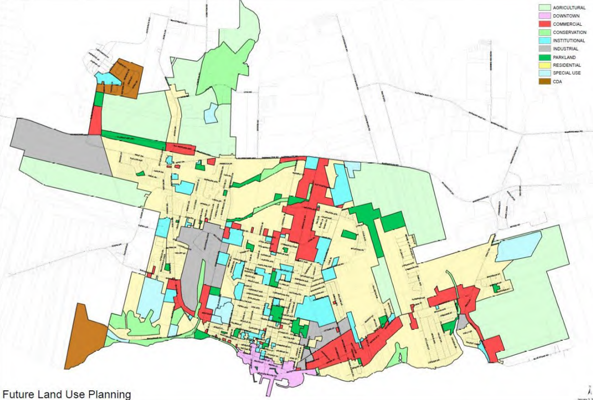
Future Lane Use Plan (p. 160 of the Official Plan)

Future Land Use Plan

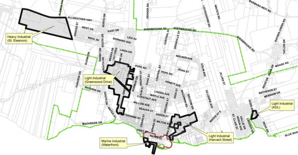
The City’s future industrial areas are shown on the Future Land Use Plan (FLUP). They include all presently zoned industrial lands and additions to the Greenwood Drive industrial area.

City of Summerside Industrial Map

Summerside Industrial Map


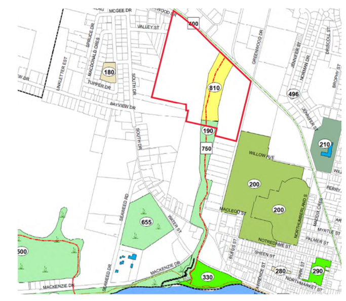
Parks and Greenspace Plan Section 7.3.2 indicates a future conservation area (Ice Pond Conservation Area Extension - 810) to the existing Ice Pond Conservation Area - 190. Section 7.3.3 indicates the Ice Pond Greenway – 750, would run from Greenshore Park – 330 to the Confederation Trail – 400 [SAFE Notes:  Often arguments are made to use the Confederation Trail instead of creating an AT route when the Confederation Trail offers somewhat similar destinations.  The same argument can be made in this case. Why would the City be exploring a Recreational Trail that runs parallel to the AT pathway on Greenwood Drive?  Our theory is that a recreational trail and an AT pathway provide two different experiences and objectives.}

Parks and Greenspace Plan Future Conservation Area

Summerside Greenspace Plan

Staff Comments: Compatibility of the proposed development with surrounding land uses, including both existing and projected
uses.
The subject property abuts two existing land uses, the land use to the immediate east, south and north are Light Industrial. The land uses to the immediate west is low density residential land uses. The change from Light Industrial to Residential land use would be compatible with the abutting existing residential and may not be considered Light Industrial land use, however the Confederation Trail and Greenwood Drive would act as a buffer between the Light Industrial and proposed Residential land uses. The subject property is intended to be further subdivided and will be subject to a major subdivision process upon development. The subject property land use is Industrial however it has been utilized as
farm land for several years. Consideration should be given to maintaining a portion of the M1 land running parallel to Greenwood Dr. or a plan to add M1 lands elsewhere in the City.

Staff Comments: Any comments from residents or other interested persons.  A public meeting was held on March 28, 2023. The public meeting notice was advertised in the March 15th, edition of the Guardian. Thirty (30) letters were mailed to twenty-nine (29) property owners. Peter Brown, presented, on behalf of Clifford McQuaid (Camco Inc.), an overview of the development and noted that the housing is needed in the Community
and the proposed development is intended to be energy efficient by means of a community owned energy service. Harold Grant (74 Lockwood Dr) asked how the construction equipment would enter the property and hoped it would be off Greenwood Dr and not Valley or Lockwood. He also indicated he would rather see residential development rather than commercial. Don Ashley (53 Lockwood Dr) asked for clarity on the energy efficient component. Judy Peters (53 Lockwood Dr) is opposed to this development being connected to Valley St or Lockwood Dr. Michel Vaillancourt (41 Valley St) asked why Council would consider changing the zoning from M1 to residential, as there is no other residential housing on this section of Greenwood Dr. (Notre Dame to Pope Road). A resident of 41 Valley St expressed concerns on Valley St being too narrow to handle the proposed additional traffic from this development, and has concerns for pedestrian safety and wildlife habitat on the subject property. Councillor MacDougall had concerns regarding the proposed connection of the development to Valley and Lockwood.

STAFF REVIEW: City Staff are not opposed to the applications, from Camco Inc. for PID #69781 in entirety, to rezone to a mix of Service Commercial, Low Density Mixed Residential (R2) zone, High Density Residential (R4) and Medium Density Narrow Lot Density (R3r). Staff caution Council on rezoning the Light Industrial (M1) lands along Greenwood Drive for residential development. Please find the Planning Officer’s comments below regarding the current M1 zoned lands. Comments from Economic Development staff, were not available at the time of this report being submitted, comments will be provided to Mayor and Council prior to the planning board meeting.

Planning Officer Comments: The subject property is approximately 60 acres in area, approximately 30 acres is buildable area. At the time of the original official plan in 1998, it has been Council’s intention for this property to be future expansion of the Pope Road/Greenwood Drive industrial park. Council’s policies noted in this report, do not explicitly prohibit Council from changing the official plan future land use map from industrial to residential with respect to the current application. However, removing 30 acres of employment lands (industrial) and designating to residential does not align with Council’s Economic Growth Strategy in Section 3.7.1 of the official plan and policy #7 highlighted above.

If Council approves this change to the official plan Future Land Use Plan map (Schedule ‘B’), it is recommended:
1. Council direct staff to start identifying potential new industrial growth areas on the future land use plan that make up the equivalent 30 acres being re-designated to commercial/residential.
2. The text of the official plan in Section 5.6 for industrial lands would need to be amended, as well as the map Figure noted above. Recommendations #1 and #2, could occur at the time of the official plan 5-year general review in 2023.
3. As a final recommendation and caution, location and zoning of new industrial lands is not a straightforward process. Residents will have concerns of new industrial zoned lands if located near residential zoned areas. The outskirts of the City or agricultural lands may have the land mass required, but may have costly servicing constraints or provincial highway access issues.

PLANNING BOARD RECOMMENDATION: The application received from Camco Inc. for PID #69781 to amend the City Official Plan from Industrial land use to a mix of Commercial and Residential land use and the Zoning Bylaw from Light Industrial (M1) zone to a mix of Low Density Mixed Residential (R2) zone, High Density Residential (R4) zone and Medium Density Narrow Lot Residential (R3r) zone be recommended to be approved by Council:   Moved by: Mayor Kutcher Seconded by: Deputy Mayor Snow (the corrected recommendation read at the April 11, 2023, Planning Board Meeting.)

Discussion: 

  • Councillor MacDougall stated that at the last meeting, residents spoke against the street going through and that he supports them. He said it was a big issue last time it came through. He stated he supports the rezoning but does not support a street coming through Valley Street.
  • Councillor Doiron stated that there could be an industrial development in that area with the roads joined up. Staff stated that an M1 development could come forward tomorrow and the roads could still be proposed to come though Valley and Lockwood.
  • Councillor MacDougall inquired what 810 meant on the map that was displayed. Staff stated that there may be a walkway required with the trail, ice pond and Greens Shore.

The planning board recommendation whether carried or defeated will be brought forward to Council for a final decision. (SAFE NOTES: Cannot seem to locate when this issue was brought back to Council but work has begun in this area.)

  
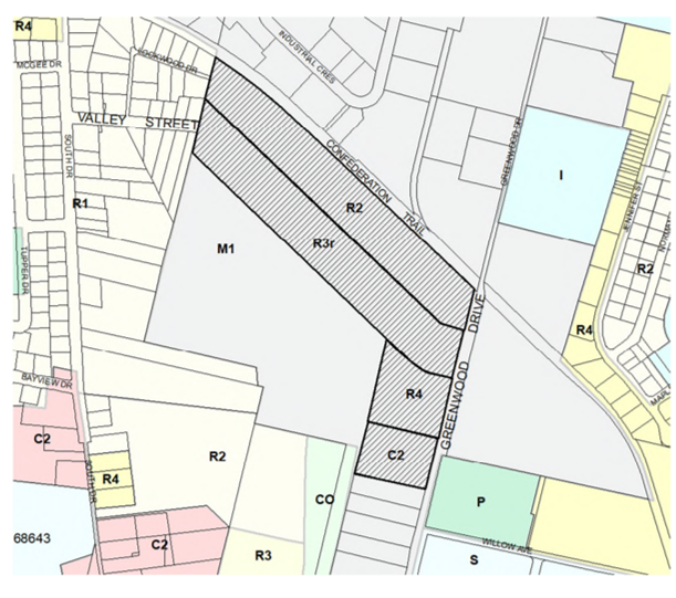
April 5, 2023: a SAFE member witnessed, and reported to the Police, a youth on an e-scooter being hit by a motor vehicle in the parking lot of the PEI Cannabis Store.  SAFE Summerside further sent a detailed communication to all City Councillors concerning this incident, and the need to move forward on safe active transportation.

April 17,  2023: Council Meeting
Additional Info: Information Package & Meeting Video [ Minutes ]

 
The Summerside Intermediate School Junior Council Mayor Adia Laureijs stated as one of the goals of the Junior City Council would be “to widen and improve transportation options for our citizens . . . We should continue to encourage active transportation like walking and biking by building more sidewalks and bike-friendly options,” 

TRAFFIC SAFETY ISSUES FOOD TRUCK AT CENTRAL/WALKER AVE
Councillor Gallant stated that she witnessed two near accidents in 15 minutes at Central Street / Walker Ave and is concerned about supporting this development (1:00:30)

Councillor McColeman stated she would not be voting in favour of letting it go forward because of safety, "I have watched traffic entering and exiting," and the change in residential to the commercial unit (1:01:00).

Both Councillor Gallant and Councillor McColeman voted against, all other Councils voted for (Council MacDougall not present to vote).

For Reference: 

Junior Mayors of the Town of Summerside

  • 1967 - Parker Rodd
  • 1982 - Robert Richard
  • 1983 - Aaron Driscoll
  • 1984 - Stephen Campbell
  • 1985 - David Gillis
  • 1986 - Corey Palmer
  • 1987 - Rod Gallant
  • 1988 - Paul Doucette
  • 1989 - Laurie Hickey
  • 1990 - Lori Campbell
  • 1991 - Angele Gamble
  • 1992 - Renee Allen
  • 1993 - Jennifer MacAusland
  • 1994 - Jimmy Arsenault

Junior Mayors of the City of Summerside

  • 1995 - Scott Hastings
  • 1996 - Mark Greenan
  • 1997 - Blake DesRoches
  • 1998 - David Clark
  • 1999 - Jillian Shaw
  • 2000 - Adam Lyle
  • 2001 - Will Arsenault
  • 2002 - Tyler Murphy
  • 2003 - Darren Riley
  • 2004 - Adam Casey
  • 2005 - Brett Carragher
  • 2006 - Carley Furlong
  • 2007 - Wayne Gallant
  • 2008 - Taylor Stright
  • 2009 - Brendan Ronahan
  • 2010 - Santana Muttart
  • 2011 - Noah Richardson
  • 2012 - Umara Muhammad
  • 2013 - Hannah Taylor
  • 2014 - Lauryn Reeves
  • 2015 - Ethan Boyd
  • 2016 - Sarah Hall
  • 2017 - Trent Baker
  • 2018 - Anna Clark
  • 2019 - Nathan Wright
  • 2020 – ??
  • 2021 – Donovan Ryder-Clements
  • 2022 – Alivia Johnston
  • 2023 – Adia Laureijs
  • 2024 - Hunter Sparkes


May 2,  2023: Committee of the Whole
Additional Info: Information Package & Meeting Video [ Minutes ]


Parking Northside of Green Street
Continued parking changes were introduced near Parkside Elementary School as per the recommendation of Chief Walker based on the request of Parkside Elementary to make the area safer for the children exiting the vehicles and limit crossing the road. Councillor Snow expressed short-term, 15-min parking, as an option to prevent others from parking long-term and thus "occupying the space" and making it unavailable to student drop-off.   Councillor MacDougall shared Councillor Snow's feelings.  Councillor Snow suggested asking Parkside if Parkside would rather (1) parking all the time or (b) parking only as drop off.  Approved on May 15 Council Meeting unanimously.

Green Street Parking

MacKenzie Drive speeding/traffic calming (Councillor MacDougall)
Councillor MacDougall asked if it were possible to add a temporary speed hump on MacKenzie Drive and was seeking the support of City Council.  Mayor Kutcher said, "Here we have another street built to accommodate motor vehicles as opposed to the safety of residents.  A wide street and no sidewalk. .... 90% of the time a pedestrian is hit with a motor vehicle going under  40 km/h, the pedestrian survives, over 40 km/h significantly increases the risk."  There was no vote, but Council members said they would support speed humps.  The decision seemed to be to use MacKenzie Drive to use various types of traffic calming to determine the best possible solution. There was also a discussion on the traffic calming measures placed on Craig Ave last year, but the residents do not wish them to be returned this year, Councillor Gallant explained.  Gallant also said there is a traffic concern in the Hillcrest area that there will be an accident.  There was also a reference to the fact that 3D crosswalks did not create increased safety.  


May 15,  2023: Monthly Council Meeting
Additional Info: Information Package & Meeting Video [ Minutes ]

 
"Go Fish Eatery" Food Truck application (valid for one year) in the parking area connected to the Baywalk Trail entrance/exit parking location received unanimous approval (location highlighted in yellow):

Food Truck

Emergency Services (Councillor Adams)
We have seen a substantial increase in traffic enforcement since the implementation of the Traffic Section. In 2022 from January 1st. to the end of April there were 301 tickets issued and 76 written warnings. In the same timeframe in 2023, there were 616 tickets issued and 193 written warnings. Traffic enforcement has doubled in the city since the Traffic Section was put in place.

Homelessness in Sside
Ivy Inkpen's passion and compassion for homeless people can be listened to at the end of the Council Meeting (1:38:00 to 1:43:00 mark in the video).

   
May 24, 2023: $7M+ in Active Transportation from the Province (news release).

May 29, 2023: Nick Cameron becomes City Councillor for Ward 3 following By-Election.

June 4, 2023: A pedestrian hit by a driver of a Motor Vehicle in the Silver Fox parking lot, and left the scene of the accident.  The pedestrian was seriously injured, and listed in critical condition in a Moncton hospital.  The driver was arrested.   Police said the man is expected to be charged with dangerous driving causing bodily harm, failure to stop after an accident causing bodily harm, and assault with a weapon causing bodily harm.  (CBC news)

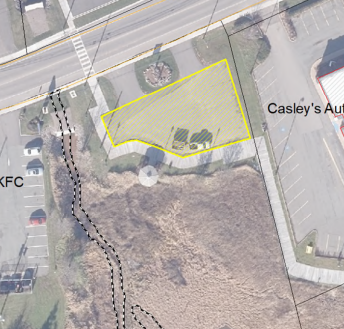
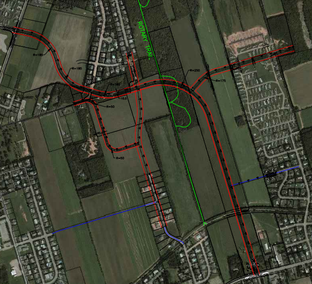
June 6,  2023: Planning Board / Committee of the Whole
Additional Info: Information Package & Meeting Video  [ Minutes ]

 
Planning Board

Of interest, a Medical Office/Pharmacy and Rental Space was proposed at 433-447 Water Street (the location of the old Scooter Depot).  The Planning Board carried forward unanimously and was approved by Council on June 19.

East West Connector Update

In 2008 the East West Connector Street Plan was approved by City Council. In that document, it suggests the creation of a connector zone, specifically for the properties directly abung this new street. The width of this zone would be 61 m (200 feet), on both sides of the new street. Since then, we have not created the zoning that was suggested. It was presented to Technical Services Committee in 2009 and has not been moved beyond that date. Now that the project has been budgeted for this year, and the design is continuing for the East West connector project, it is time to start the process of getting the associated zoning in place for this development area  (200 feet along the flow of the road), Page 3 of Info Package).

East West Connector

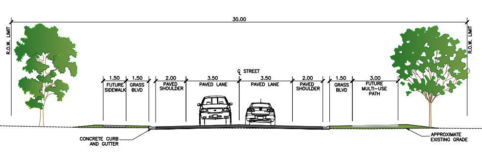
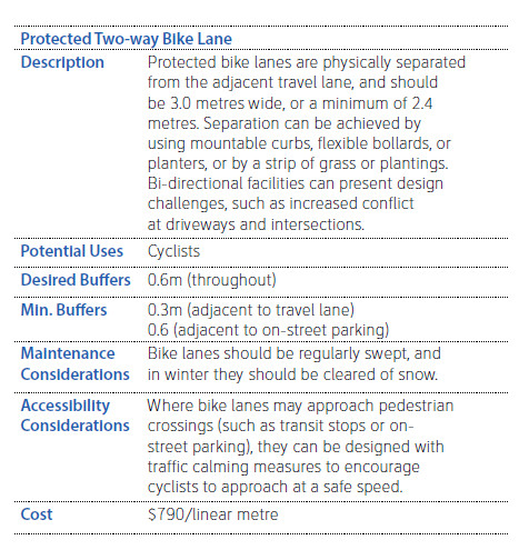
Rotary Friendship Park - the intent would be to maintain the trail with the possibility of creating a parking lot where the East West Connector and Trail cross (decisions to be made at a later date).

SAFE NOTES: The current plan for the road includes a bi-directional (3.0 meters) AT Pathway.  (We at SAFE celebrate this!  This is the first new street designed with AT in mind! ) 3.0 meters for a bi-directional is the desired width according to the PEI AT Network Plan and national standards (BC and QC).  However, because of contraflow traffic issues and the risk of AT user injury,  more caution and consideration needs to occur - we recommend a unidirectional on the new corridor.   Proposed Layout

Committee of the Whole

Three Current Committees:
Committee of the Whole
Finance
Planning Board

Mayor Kutcher will introduce two new Committees:
ByLaw and Governance (new)
Priorities and Planning (new) - help identify when things need to move where


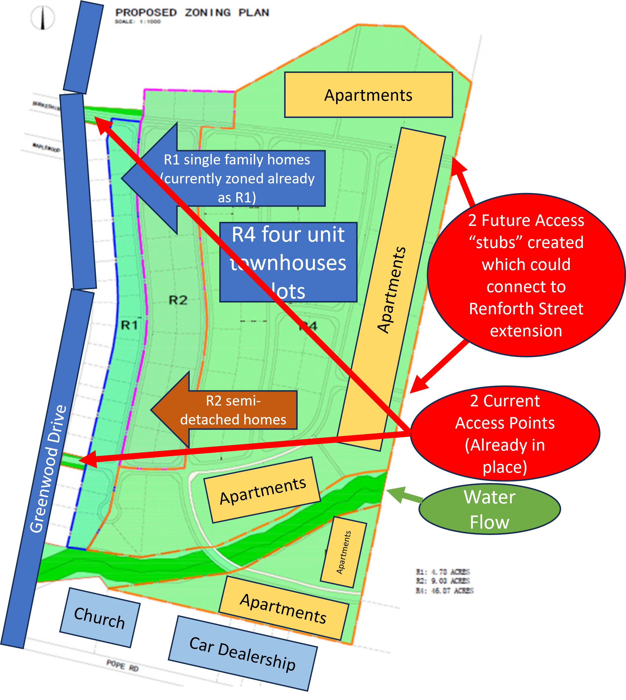
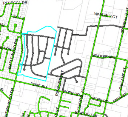
June 14,  2023: Special Council Meeting - 255 Greenwood Drive (Rezoning Amendments)
Additional Info: Information Package & Meeting Video [ Minutes ]

 
Proposal to build over the next 10 years, 600 units, including single family homes, semi-detached homes, four until townhouses, and 17 apartment buildings (24 units each).

Residents stated safety concerns with the Pope Road/Greenwood Drive intersection, and how narrow Greenwood Drive is, and residents shared it was not safe currently. Councillor Dorion stated he supports traffic lights at the Pope / Greenwood intersection.

Traffic concerns were raised on the impact of increased traffic on Pope Road and Greenwood Drive not being able to accommodate the added traffic.

Councillor MacDougall reported there continues to be a concern with the growing traffic on Pope Road and South Drive.

Developers recognized the need to work with the residents, the City, and make amendments to their proposal.

 Upper Greenwood Drive Proposal

Council passed the resolutions to bring the rezoning application to the Planning Board Meeting.

Planning Board Meeting (June 27) (Meeting Package) (Meeting Video) [ Minutes]

3 Key Criteria Applicable in this application for locating high density housing in the City of Summerside include:

  1. the desirability of locating high density housing close to jobs, community facilities and services, and of
    promoting pedestrian access;
  2. the benefits of locating higher density housing in difficult-to-service areas so that they can help distribute
    expensive development costs among more users;
  3. avoidance of negative economic and physical impacts on surrounding land uses, whether existing or
    proposed;

Staff Comments: 

ADEQUACY OF EXISTING WATER, SEWER, ROAD, STORM WATER and ELECTRICAL SERVICES
The zoning change represents an increase in sewer loading of approximately 23% for this rezoned area which translates to a $260,500 cost to the sewer utility and an increase in water demand of approximately 33% for the rezoned area which translates to a $122,000 cost to the water utility. The city’s sewage collection and treatment systems have the capacity to handle the additional loading from the zoning changes and the city’s water supply system has the capacity to handle the additional water demand from this rezoning.

TRAFFIC VOLUME REVIEW
Current Existing Traffic volume is 1,424 Vehicles Per Day; The change in development volume due re-zoning will increase by 2304 vehicles per day (VPD). For this review all the development traffic is assumed to exit through Greenwood Drive, but this may change when the neighboring property to the east is developed.

GREENWOOD DRIVE
Greenwood Drive is a local City Street with a capacity of 10,000 Vehicles per Day. The current volume for this section of Greenwood Drive is 1,431 VPD approximately based on recent traffic counts completed on this section of street.

Total volume increases on Greenwood drive from 1,431 VPD to 5,159 VPD.
Total volume increase due to zoning change would be 2,304 VPD.

Approximate % increase of volume from this zone changes 23.0 % of the total street capacity at full development.
Approximate % of volume from existing residents currently 14.3 % of the total street capacity at full development.
The approximate total capacity of Greenwood Dr. would be 51.6 % at full development 

Impacts from the development on pedestrian/vehicular access and safety, and on public safety generally.
Vehicle access from the development will be in two locations to Greenwood Drive forming one new four-way and one new three-way intersections. The development concept plan also has three locations connection to the neighbouring property to the east which in future will have connection to both Pope Road and Central Street (noted above in section f.) As shown in the traffic volume review, the new development will add approximately 37.3 % of the total capacity of Greenwood Drive and with the change in zoning to a higher density zoning, the city’s sidewalk network should be eventually extended to connect these highdensity areas. This development is to be phased in over the next ten years, there is a sidewalk on the west side of Greenwood Drive, from Pope Road to the south leg of Maplewood Drive and the city should plan to extend the sidewalk to these higher density buildings over the developments building phased timelines. While this development does not impact the Parks and Green Space Plan, as the Parklands will remain as is, there is a future trail “Platte River Greenway” – 740 along the south drainageway from Greenwood Drive to Central Street, intended as a pedestrian walkway (see map extract below, form Parks and Greenspace Plan). The City’s Fire and Police Services will grow as resources allow to support growing population.

Of interest, the property rezoning application is highlighted in blue, and a separate land development plan by a different private contractor is also included in the grey lines to highlight the potential access points and connections.  With these future plans, there would be five exit and extry points.

Proposed Future


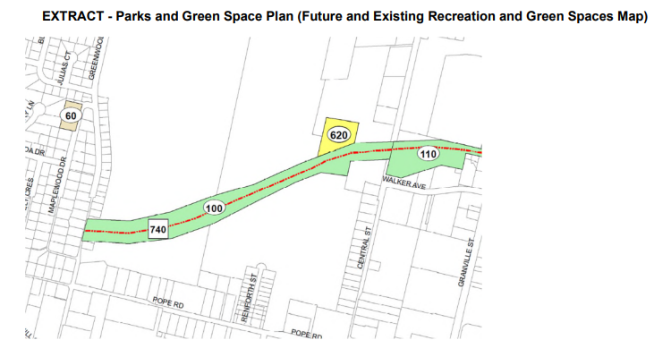
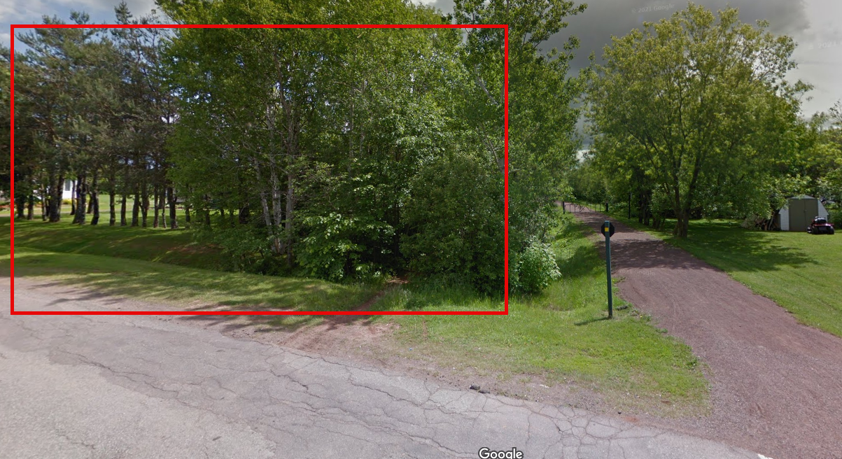
The Meeting Package highlights the image that follows is an extract from the Parks and Greenspace Plan that highlights a "pedestrian walkway" from Granville Street to Greenwood Drive.  In fact, this is the Map from the draft City of Summerside Active Transportation Plan, 2012 (p. 33) as there is no such Map in the Parks and Greenspace Plan; however, the Platte River Greenway is listed in the Parks and Greenspace Plan (SAFE is encouraged to see this Greenway is still in the works but hopes the pedestrian walkway would be a multi-use AT pathway):

Parks and Green Space Plan Extract

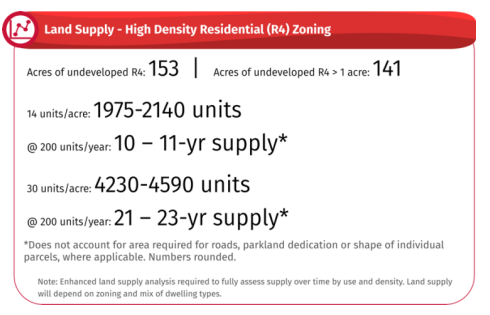
STAFF REVIEW: City staff supports the application for a portion of PID #1163526 to amend the City Zoning Bylaw from Single Family Residential (R1) zone to Low Density Residential (R2) zone. Staff do not support the application for portions of PID #1163526 to amend the City Zoning Bylaw from Single Family Residential (R1) zone to High Density Residential (R4) zone and from Low Density Residential (R2) zone to High Density Residential (R4) zone as shown on the applicant’s plan. 

PLANNING BOARD RECOMMENDATION: 

The proposed R1 to R2 is recommended by the Planning Board by 3 to 1.

The proposed R1 to R4, and R2 to R4, are not recommended by the Planning Board by 4 to 0.

Mayor Dan Kutcher spoke for 56 minutes to provide his comments as a member of the Planning Board on this rezoning application (begins at the 49-minute mark of the video).  We highlight the comments related to active transportation below:

  • "In the past, this area may have been the suburbs, but it is not anymore.  This development is very close to a commercial centre (Gospel Chruch, car dealership, and the city's major employer the GST Centre).  The goal of high destiny housing is to make sure that people who work at these places and live close to them so they can walk to these places . . . we want more people walking place to place, that we have our communities more walkable, and reduce our impact on the environment by reducing our dependency on cars, and that we put people close to where they work."  (1:17:25)
  • "Increased traffic is a real concern. I think Greenwood Drive itself, north of Pope, is particularly troublesome because of the proximity of the ditches to the roads.  It is a dangerous place to walk." (1:20:15)

Now, a snapshot of the housing needs for Summerside, as detailed by Mayor Kutcher:
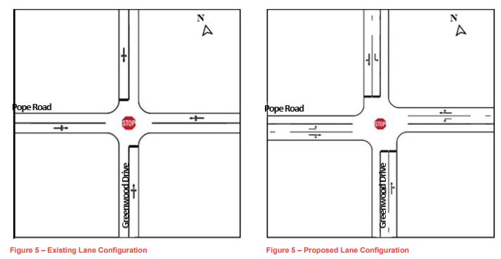
  • 1,900 new housing units by 2031 (190 units /year)
  • 165 units in 2023 in Summerside -- so we are falling further behind
  • housing will be the largest challenge of this Council and the years ahead (1:35:27)

GREENWOOD and POPE INTERSECTION
Of note, a review of the intersection of Greenwood Drive and Pope Road was undertaken by WSP in 2019. The review was to consider what modifications could be considered to the traffic control, intersection geometry, and lane alignment to improve traffic flow at this location.

As quoted in the Memo from Aaron MacDonald to Bob Ashley: 
The consultants collected the intersection turning movement and pedestrian counts during the morning, midday, and evening peak hours. The volume split between the major street (Pope Road) and the minor street (Greenwood drive) was found to be 82% / 18%. To estimate the design hourly volumes (DHVs) at the intersection, a factor of 1.1 (10% increase in volumes) has been applied to the 2019 observed average traffic volumes. This data was used to complete a Left Turn Lane (LTL) warrant analysis for the major street (Pope Road) approaches.

The data was also used to complete an All – Way Stop Warrant analysis. As a rule, an All-Way STOP is best suited for an intersection where approach volumes are balanced with about 50% of the intersection approach volume on the major street and about 50% on the minor street approaches. A Transportation Association of Canada (TAC) AllWay STOP control warrant for the intersection of Pope Road at Greenwood Drive was prepared considering the 2019 average counts with 10% growth, and a lane configuration with single shared lane for right turns and through movements and an exclusive left turn lane on all approaches.

The data was also used to complete a Signal Warrant Analysis. The intersection review included completion of a traffic signal warrant analysis to consider whether traffic signals are the optimal form of traffic control. The signal warrant analysis uses vehicular and pedestrian volumes, and intersection, roadway and study area characteristics to calculate a warrant point value. An additional signal warrant was conducted to determine if traffic signals would be warranted under this lane configuration and forecasted future traffic volumes (DHVs with 30% growth) to reflect a horizon year. A growth factor of 1.3 (30% increase in volumes) has been applied to the DHVs to reflect future conditions.

Greenwood and Pope Road Intersecton

SUMMARY and Upgrade Options
Overall the intersection should be planned for future signal installation with left turn lanes on all approaches. The analysis indicated that installing unwarranted traffic signals now is shown to increase the overall intersection delay, whereas adding traffic signals in the future, when traffic volumes increase, is shown to reduce overall delays when compared to the unsignalized intersection.  While a roundabout analysis was not completed, the volumes are not balanced and would result in higher through traffic. In addition, it is expected that there is no adequate land available for the installation of a roundabout. The cost for widening and adding left turn lanes to all the approaches is estimated to be in the range of $100,000. With the geometric upgrades of the added left turn lanes already being constructed, the addition of traffic signals in the future is estimated to be in the range of an additional $150,000.


June 19,  2023: Monthly Council Meeting
Additional Info: Information Package & Meeting Video [ Minutes ]

 
CLOSED-DOOR ACTIVE TRANSPORTATION MEETING
There was an in-camera (closed-door session) on Active Transportation Provincial government funding.  The session was closed based on the Municipal Government Act Sec 119 1(e): "a matter still under consideration, on which the council has not yet publicly announced a decision, and about which discussion in public would likely prejudice a municipality’s ability to carry out its negotiations"    By the nature of a closed-door session, this information has not been made public. 

Appointment of Committees

Priorities and Planning (new Committee)
Mayor Kutcher (Chair)
Deputy Mayor Snow (Vice-Chair)

Bylaw and Governance (new Committee)
Councillor Adams (Chair)
Councillor Cameron (Vice-Chair)

Finance
Councillor MacDougall (Chair)
Council McColeman (Vice Chair)
Councillor Gallant (new appointment)

2023 City Road Work
Map of proposed City of Summerside road work for 2023 (or, a text version).


July 4,  2023: Committee of the Whole and Special Council Meeting
Additional Info: Information Package & Meeting Video  [ Minutes ]

COMMITTEE OF THE WHOLE

Summerside Transit Update (presented by Mike Thususka, Dir Economic Development)
The Transit Committee is recommending a Hybrid system with fixed routing (red line) and an on-demand service (yellow) at 45-minute intervals utilizing a two-bus active and two-bus standby. Hours 8 am to 545 pm (fixed) 8 am to 600 pm (demand).  The average fare of $2.  The Bus fleet would be 30-foot all-electric (zero emissions) and low-floor accessible. The City would own the fleet, but the service be contracted out to the private sector to run the system. Cost: $1.7M  50,000 is estimated as ridership. 

Transit Map2023 Updated Transit Route

(the above photo is not of great quality, as the 2023 update does not seem to be available online; so, we took a screenshot from a PowerPoint presentation. The 2021 Report can be found here. )

We can see a major difference in the 2023 proposed single route with the 2021 proposed two route map:

2021 Map
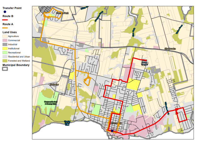
2021 Transit Map Route

All Councillors supported moving ahead on the 2023 Transit Update, and recommending that Staff research available funding options, and bring it back to Council. 

Sidewalks on Driveways
Councillor Morrison asked "why" the City completes sidewalks by putting concrete down in people's driveways.  The city staff explained it creates a right of way or a way to highlight that motorists be ready to expect a pedestrian as it is the city's legal responsibility to ensure a clear path for pedestrians, and decrease a city's liability for risk and falls. Morrison explained we do not have sidewalks cross over intersections, and suggested putting sidewalks on other streets without sidewalks by not putting sidewalks on people's driveways. Staff to bring back more information to which Council can direct on wishes.

Universal Basic Income Resolution
Mayor Kutcher brought forward this item. Council supported bringing the resolution to the next Council Meeting

SPECIAL COUNCIL MEETING

Two Resolutions from R1 to R2 - Council voted 7 to 1 in favour. Councillor Doiron did not support these Resolutions based on comments from residents and the impact on pedestrian and vehicular safety.

All Resolutions from R1 to R4 - Council unanimously did not support any of the Resolutions.


July 17, 2023: Monthly Council Meeting
Additional Info: Information Package & Meeting Video  [ Minutes ]

 
Creation & Appointment of AD-HOC Committees

Downtown Waterfront Revitalization Committee,  Chair: DM Snow
Welcoming Diverse and Inclusive Communities Committer Chair: Cameron

Two RESOLUTIONS Approved: 

UNIVERSAL BASIC INCOME
Be it resolved that the Council of the City of Summerside direct the Office of the Mayor to write a leer to the Prime Minister, the PEI Members of Parliament, and the Premier of Prince Edward Island, calling on these orders of government to work towards developing a Guaranteed Livable Basic Income to eradicate poverty and homelessness, and ensure everyone has sufficient income to meet their basic needs. Council approved Unanimously.

PRIDE WEEK
BE IT RESOLVED by the City of Summerside that:
1. The City of Summerside shall fly the Pride flag annually during Pride Week, commencing on the beginning of Pride week each year. The Pride flag shall be prominently displayed at designated locations, including City Hall and other public buildings as deemed appropriate by the City administration.
2. The City of Summerside shall adopt visible pride symbols and decorations throughout the city, including but not limited to, banners, signs, and artwork, during Pride Week. These symbols shall be displayed in public spaces, parks, streets, and other areas within the city, contributing to the atmosphere of inclusivity and support for the 2SLGBTQIA+ community.
3. The City administration is directed to coordinate with local 2SLGBTQIA+ organizations, community groups, and residents to ensure that Pride Week activities and events are well-publicized and effectively promoted. Collaboration shall be encouraged to ensure a diverse range of perspectives and experiences are included in the planning and execution of Pride Week initiatives.
4. The City administration is authorized to allocate resources, within existing budgetary constraints, to support the implementation of this resolution, including the acquisition, installation, and maintenance of Pride flags, decorations, and other related items.
5. The City administration shall review and evaluate the effectiveness of these pride visibility measures annually, ensuring that they continue to align with the city's commitment to inclusivity and the needs of the 2SLGBTQIA+ community. Council passed the resolution 7-1 (Councillor McColeman voted against the resolution).  

STORM (Ditch Infilling) COMMITTEE
(background provided)

"The Committee recommended two different streams ( [1] cost share: 75% city, 25% property owner to a max City contribution $4,500; [2] other property owners, 50% cost share to max city contribution $3,000) based primarily on the historic “promise” that is noted by many involved residents and Councillors past and present. The committee expects that this option may not completely satisfy all residents but believes it strikes the right balance when all factors are considered.  It should also be noted that as the City continues to grow our network of sidewalks and active transportation routes there may be cases where a ditch is required to be infilled to make a sidewalk possible. In these instances, the City would cover 100% of the costs."   Councillors will vote on this issue at the September Council meeting.  


July 21, 2023 -- POPE ROAD ACTIVE TRANSPORTATION EXTENSION > Survey crews (ground & arial) have begun work on Pope Road between Central St and South Dr in preparation for the Active Transportation extension. The work is expected to be ongoing for the next couple of weeks. (City of Summerside Facebook Notice).


July 28, 2023 -- CRAIG AVE. TRAFFIC CALMING MEASURES > Traffic Calming Devices reinstated on Craig Avenue to control the excessive speed in the area. These devices will be in place until early November. (City of Summerside Facebook Public Notice)

Craig Ave Traffic Calming

 PEI Flag Provincial News: July 31, 2023-Aug 8: Fourth Serious Collision Between Pedestrians/Cyclists in Two Weeks on PEI

Four serious incidents in PEI in two weeks:

  1. A woman was killed on a sidewalk when a trailer detached from a truck and struck her on Mount Edward Road at 745 am on July 25 (CBC News)
  2. A male pedestrian died in a collision on Union Road in St. Edward, southwest of Tignish, on July 27 (CBC News)
  3. A male cyclist was hit by a pickup truck on Route 2 near Scotchfort just after 4 pm on Sunday, July 30. Serious to a stable condition. (CBC News)
  4. A male cyclist was hit by a motor vehicle in Warren Grove. August 8. Airlifted to Halifax (CBC News


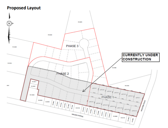
August 9, 2023: Special Council Meeting
Additional Info: Information Package & Meeting Video  [ Minutes ]

 
SAFE sent the following communication to the City, Mayor, and Chair of the Planning Board (on Aug 5)

Our All Ages and All Abilities AT Network Plan proposes a safe AT route from Gallant Street through to the Walmart Parking lot, utilizing currently a grass trail on private property, but with this development, we see great potential for the route to be paved via the connector road as indicated in the proposed layout:
 
Walker Ave
 
The concern (or, more precisely, an opportunity) comes that this application is for the rezoning of the subject property that falls directly on our proposed safe AT Route:
 
 Walker Rezoning
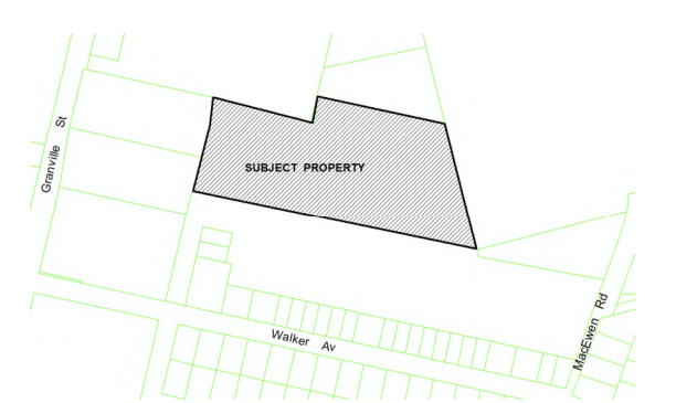
We sent an email to Staff and Council asking if Staff and Council so thought it of benefit to add a caveat to the discussion/criteria, if approved, that space for a potential AT lane be created alongside the apartment building to support the safe AT route.  Much like criteria would be added to support the Greenspace Plan in other properties.  This appears to be the easiest (lowest cost) and safest alternative to having AT traffic on upper Granville Street. 


August 21, 2023: Planning Board & Monthly Council Meeting
Additional Info: Information Package & Meeting Video  [ Minutes ]


PLANNING BOARD re: 121 Walker Avenue (Rezoing)(see above Aug 9th note) 

Staff comments in their recommendations:  "The request for the City to consider a public bike route [Active Transporation Pathway] from Walker Av. to Walmart, can be reviewed when the subject property is further developed. The extension of Gallant St. and the future street (Key Avenue), currently under construction, will become public street which will allow public access."  

A copy of the email SAFE sent to the Mayor, Councillor Dorion, CAO MacFarlane, and CAO Desrosiers is contained in the information package.  In response to Mayor Kutcher's questions, the new road (The Key Ave.) would not have a sidewalk, and the opportunity to build an AT network from Gallant St. to Walmart (if so desired by the City) could be incorporated when the subject property development moves forward.  Mayor Kutcher stated, "it does concern me a little . . . that there this [new housing development] will not have sidewalks (33:50)". 

The recommendation to send the Rezoning Application to Council was approved unanimously. 

COUNCIL MEETING

Councillor Adams stated she voted in opposition to a bylaw zoning amendment because "there are constant safety issues with the traffic volume on Water Street East. . . . this amendment would only exasperate the ongoing traffic and safety issues that are experienced daily by residents, pedestrians, and the traveling public . . . (1:52:30) 
 
Police Services Report: "A comparison of enforcement numbers have been completed for January 1st 2022 to July 31, 2022 and January 1st, 2023 to July 31st, 2023. In 2022 a total of 570 charges were laid and 95 warning were issued. During the same time period in 2023 with the new Traffic Unit in place 980 charges were laid and 480 warnings were issued. The number of complaints from the public regarding speeding within the city has dropped significantly. We have been targeting problem areas with information received from the public and by using data created by Technical Services."


September 5, 2023: Planning Board, Special Council, & Committee of the Whole
Additional Info: Information Package & Meeting Video  [ Minutes ]

Five Conservation Areas in the City (Sec 5.11):
Conservation areas are intended to cover situations on privately owned lands where local environmental conditions are considered to be: (a)hazardous to development, and/or(b)vulnerable to damage by development. Where such lands are owned by the City or are intended to be acquired in the immediate future for public purposes, they would be designated as parkland (see Section 5.8). The Future Land Use Plan (FLUP) presently designates five conservation areas listed below:
    1. Compton Creek wetlands on Malpeque Bay
    2. Platte River floodway north of Pope Road and west of Central Street
    3. Ice Pond wetlands west of Greenwood Drive
    4. Reads Creek wetlands near Reads Corner
    5. Gillespie Creek wetlands south of Water Street West East

As outlined in Section 5, Council’s Parks and Green Space 2012 focuses on implementing a linear park system, which could include public trails on higher portions of flood greenways and wetland areas. However, Council does not commit to create public parks in the five areas identified above, and nothing in this Official Plan should be construed as implying any such intention. 

Section 7.3.3 New Greenways, Trails and Boardwalks (Policy)
A trial is proposed to run along the outside of the Gillispie Creek Conservation Area (430), with view points provided over the scenic tidal marsh area. The trail would continue northwards alongside Gillespie Creek and proceed across Water St East onto the Confederation Trial at it’s junction with the Hall Family Trail. A private owner agreement would be needed. Eastwards, sidewalks along a future street ROW (Right-of-way) would link the greenway to Crozier Drive and then onto the proposed Reads Creek Greenway (790).

Parkway

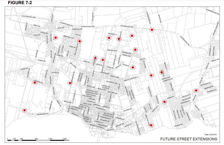
Councillor Adams asked about private owner agreement. CAO MacFarlane answered there are potential new trails mapped out but would need an agreement with private property owners before it is finalized. (22 mark)

Of interest, this map of future extensions in the City:

Future Streets

Mayor Kutcher and CAO MacFarlane discuss a trend to reduce parking maximums throughout the City, especially downtown (1:00:00 mark)

Committee of the Whole Meeting

Pope and Greenwood (Councillor Doiron)
Highlighting the need for improved traffic flow, based on messages from the community, and personal observations.  Mentioned a ballpark cost of $125,000 to install traffic signals. Did not issue a motion but wanted to express the continued concern about this intersection.  CAO MacFarlane said the WSP study highlighted when traffic increases on Greenwood, then the option of traffic lights may be introduced.

Mayor Kutcher said, "Street lights are also for helping people move safely. . . and if we want people to use fewer cars, use bicycles, we need that infrastructure." (1:40:00)

Gillespie/Water Street (Councillor Cameron)
Councillor Cameron stated he has heard from numerous rear-end accidents close to his area.  He was asking if there is something that can be done before the new development is completed (with the understanding that traffic will increase).  Councillor Cameron suggested turning lane potential for Gillespie.  CAO MacFarlane said Tech Services has been looking at this and will get back to Councillor Cameron.

Schurman Ave/Summer Street (Council Doiron)
CAO MacFarlane said staff researched this street intersection once it was added to the Agenda.  CAO reported that since Summer Street has been closed, the traffic flow has changed, and more traffic is currently on Schurman than on Summer; thus, Staff will be installing a four-way stop at this intersection.


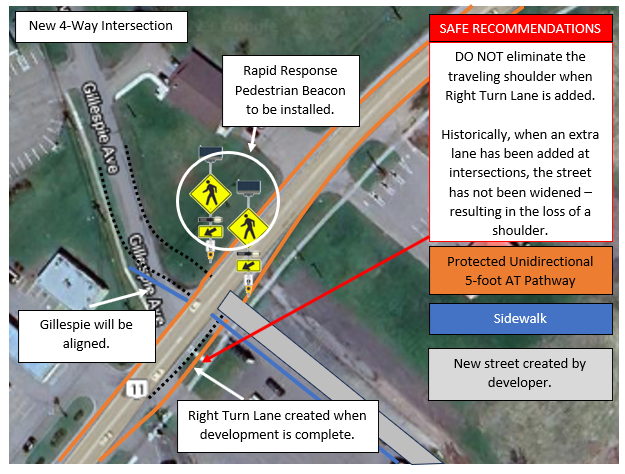
September 14, 2023: Planning Board
Additional Info: Information Package & Meeting Video  [ Minutes ]

 
Gillespie/Water Street East
The proposed street (as part of the new subdivision 678 Water Street East) is forming a new intersection with Water Street East. The City plans to realign the existing intersection of Gillespie Avenue and Water St East so the proposed street and Gillespie Avenue form a 4-way intersection. The city has available capacity for water supply and sewage disposal for this development (p. 4)

Impacts on City finances and budgets
The preliminary subdivision approval application will have an impact on City finances and budgets as the City should budget the re-alignment of Gillespie Avenue, to coincide with this proposed street construction. If future plans for road re-alignment and turning lanes are implemented, budget should be allocated for powerline modifications at this time, unless these plans can be accounted for in initial powerline construction.

 
The proposed street row accommodates a future right turn lane onto Water Street East as development occurs

Councillor Adams stated she is not in favour of this development as "it will only make traffic/pedestrian safety issues worse." "We cannot put any more traffic on Water Street East," and not supportive of the four-way intersection and the traffic issues continue. "People have problems now crossing the road; it is a recipe for disaster."
 
Councillor MacDougall stated he believes "any street going in right now should have a right turning lane."  (10:55) Aaron MacDonald stated a right turn lane on Water Street East, heading east to improve traffic flow, would only occur when the development is fully completed.
 
Mayor Kutcher said that the streets need to be integrated as Complete Streets as per the City's Official Plan and to connect to the already pedestrian network via sidewalk, and discussed the City needs to consider all development also within the lense of our Official Plan. (25:00)


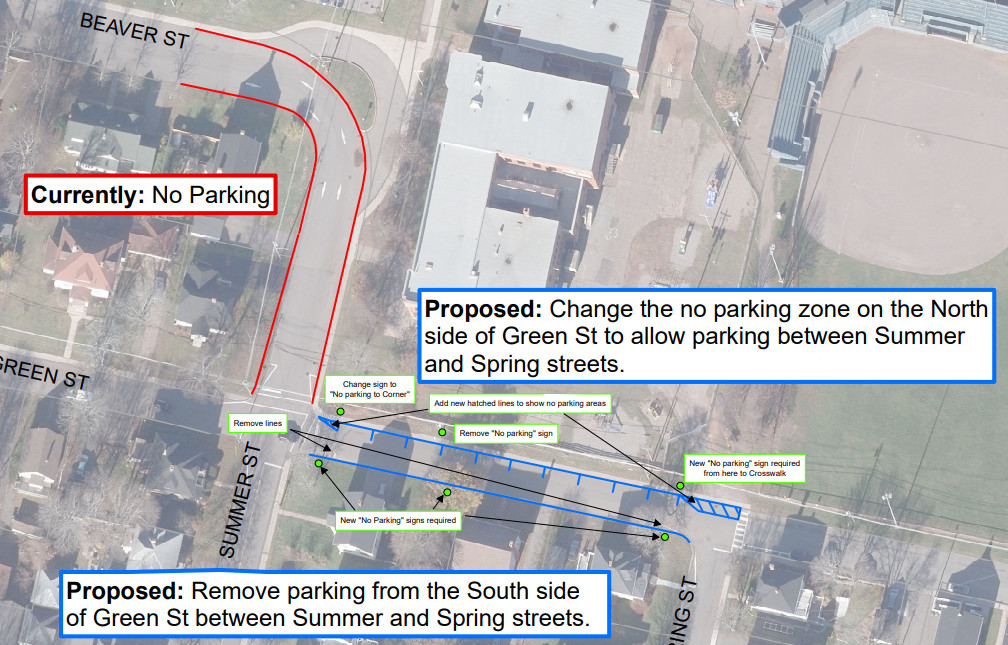
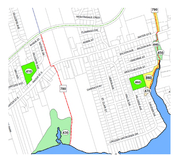
September 18, 2023: Monthly Council Meeting
Additional Info: Information Package & Meeting Video  [ Minutes ]

 
Gillespie/Water Street East Subdivision
7-1 support for items related to the development of the subdivision. Councillor Adams voted not in favour of this Resolution because of traffic concerns/safety (8:00). In other related resolutions, Councillors Adams and MacDougall voted not in favour.

SAFE Summerside created this map of the new Gillespie/Water Street East intersection with the City's plan and our recommendations.  We wish to reiterate the City of Summerside historically has eliminated travelling shoulders when extra lanes have been added in the city; we recommend the street be widened, and a shoulder lane of similar width be created.

City Plan & SAFE Recommendations


October 3, 2023: Planning Board, Committee of the Whole, Special Council Meeting
Additional Info: Information Package & Meeting Video  [ Minutes ]


Planning Board Meeting

120-unit Development at 433 Central Street
As part of the Variance Application, the applicant commented in Appendix A:

  • "With the sidewalk already in place on the proposed development side of Central St. this development contributes to the goal of creating a walkable neighborhood. Many amenities and necessities are within walking distance as well as significant employers such as the PEI Tax Center. Residents can walk to work, to shop or to receive professional services." (page 9)
  • “Encourage less emphasis on the automobile” : By building residential units in such close proximity to shopping, schools, employment and entertainment
    residents of this development can be less reliant on automobiles as a primary form of transportation (page 10)
  • As demonstrated above, this development appeals to individuals who do not own, or wish to become less reliant on an automobile as their primary form of transportation. Employment, amenities and necessities are easily within active transportation distance. (page 10)

Moved to proceed to Council Meeting (Oct 16) on the recommendations of the Planning Board. On October 16, the application for Variance was approved unanimously.

Committee of the Whole Meeting

East-West Housing Corridor Road  (1:05:00)

  • A new trailhead development for Rotary Park
  • East/West Sidewalk & Active Transporation Connectivity
  • Two streets connected to the east to Small Ave via Cardinal St and a new street created between Gordon Ave. and Brandan-Carter Ave
  • Additional egress for Small Ave. and Gillespie Ave in the future

Complete Streets Apart of our current Official Plan (Page 55) (Mayor Kutcher) (1:27:00)

Mayor Kutcher asked how do we design our streets to meet the standards/objectives of Complete Streets within the Official Plan and bring it to reality (paraphrased).  He read the articles in the Official Plan, and ended with: "All the evidence shows if you want people to slow down, [the first is to police the speed limit], the second is narrower streets that slow vehicles down."

Councillor Gallant explained there are no sidewalks on Walker Ave, Gallant Stree, or Craig Ave, and people use walkers to walk and are walking on the street and have near misses and think there should be sidewalks on these streets. (1:34:00)

Mayor Kutcher stated Complete Streets is in our Official Plan and asked how the city implements this policy as he is observing new streets created (ie, Key Ave) that do not have a sidewalk. Sent to the Planning Board, who will bring it back to the Committee of the Whole. 

History of Sidewalks (Aaron MacDonald)
Provided a history of sidewalks since amalgamation, Starting with new streets being 20 feet (6.1m) wide, ditch, and grass shoulder. People would walk on the edge of the pavement or on the grass.  Around 1997/98, this changed to streets being 8.5m (27.8 Ft)  with a curb.

Pedestrian Walkway/Active Transportation Access to Water Street East (Councillor Adams)  (1:43:10)
This has been a growing item from the community and residents have been reaching out to her.  The only way to reach the sidewalk from the south side of Water Street East (around Starlight Subdivision) is to cross down to Small Ave or by Reads Corner. Staff to create options for a RRFB to cross the street and to bring it back to Council.

Fitzroy/Granville Intersection (Councillor McColeman) (1:47:00)
A number of residents concerned about the traffic and three accidents at this intersection reported to Councillor McColeman, and echoed the voice of the citizens: "Will City Council wait until someone is killed before doing something with this."  Councillor McColeman stated the residents have asked for a four-way stop. One incident Councillor McColeman shared was of a person riding an e-bicycle.  DM Snow staing the issue is a hedge and sight lines issue. CAO MacFarlance stated that Staff received those emails already and are looking into this issue. If the hedge is following the rules, and still an issue, the City may have to adjust the rules if the hedge is impeding sight lines.

MacEwen Road traffic near schools (Councillor Morrison)
Councillor Morrison stated, "I don’t believe traffic issues in Summerside are as bad as we usually think they are." He stated residents have concerns over speeding at two school zones.  Councillor Morrison suggested speed radar signs to be installed.  Councillor Doiron highlighted the close proximity of the traffic speed from one school zone (40 kph) to a 50 kph and then to another school zone (40 kph) may be one cause of speeding.  Councillor Morrison stated, "what difference would 10 kph make?  Maybe an extra 20 seconds on MacEwen."  Mayor Kutcher responded that the 10 kph reduction "makes a big difference.  If you get hit by a car at 40 kph, you have an 8 out of 10 chance of survival; if you get hit at 50 kph, the chances you'll survive is the opposite."  The decision was Staff would look into three items: speed radar, speed zone consistency, and enforcement.


October 16, 2023: Monthly Council Meeting
Additional Info: Information Package & Meeting Video   [ Minutes ]

School Zone Change on MacEwen Road
- now runs from Athena to Three Oaks with no "break" in the school zone of 50 kph.  Now, the entire stretch of MacEwen from Athena to Three Oaks is 40 kph. 
 
New Street on MacEwen Road - "A new street on MacEwen Road has been marked for traffic signs, stop bars and paint." (SAFE NOTES: Pretty sure the "new street" is the East-West Housing Corridor (so, no signal lights)
 
The Green Commute Club concluded in late September, with 4 staff members earning free individual CUP
memberships and 27 staff members earning free family CUP memberships 


November 7, 2023: Planning Board, Committee of the Whole, Special Council Meeting
Additional Info: Information Package & Meeting Video  [ Minutes ]
 
Planning Board

Culture Summrside Strategy: 
- The City is very well equipped with cultural facilities, including the Wanda Wyatt Centre which houses the Harbourfront Theatre and the Eptek Exhibition Centre, the Lefurgey Cultural Centre, Bishop’s foundry and the Silver Fox museum. Additional attractions are being considered to support tourism, including the possibility of a discovery/ science centre in the west end of MacKenzie Drive. In 2012 the City completed a Municipal Culture Strategy. Culture can help build community ownership and pride. Culture is also an economic development strategy or often referred to as “cultural tourism”. The official plan will seek to develop cultural land use strategies as appropriate in future planning studies.
 
Committee of the Whole
 
Active Transportation Network Plan (JP Desrosiers) - 16:12 mark

Active Transportation: November 2023 Update - JP Desrosiers (Dir of Community Services)

  • Completion of Greenwood Drive (phase) spring summer of 2023, minor modifications and crosswalk painting remain.
  • Application made to the Provincial Active Transportation fund as part of 2023/2024 Budget process for an AT Pathway on Pope Road for 2023
  • Staff directed to review SAFE Summetside's proposed active Transportation Network for Summerside. (SAFE NOTES: on April 2, Staff were directed)
  • Internal staff review of the proposed AT network with feedback returned to SAFE Summerside (SAFE NOTES: on September 29, SAFE received feedback).  "We requested that SAFE Summerside present to us a prioritization of the network. It's a fairly bold and expansive plan.  It's certainly a great plan, one that we dove into pretty deeply from a staff perspective and provided some feedback back to SAFE. The reality, it will take a number of years to get a lot of that work done.  So, for us, prioritization of the plan, and getting the routes done was a critical piece of that...Our hope is to have a Network Plan in place by the New Year."
  • Lack of design standards provincially remains a challenge in development of current and future AT routes along with future planning.
  • Request by staff to have SAFE Summerside provide a prioritization of the network to help support future planning.
  • Staff received funding approval from the Provincial AT fund for Pope Rd Phase 1.   (SAFE NOTES: No information shared on what is Phase 1 of Pope Road. ie, Greenwood to Central, Greenwood to South, or Central to Granville? 
  • Funding approval was received in July 2023, thus too late for tender and construction commencement in 2023 however staff have moved forward with surveying and design for a proposed 2024 Pope Rd project. The City received approval from the Province to hold the funds until next year to begin work on Pope Road
  •  Hopes to have an AT network adopted as part of future capital planning in spring 2024.

QUESTIONS FROM COUNCIL

  • Councillor MacDougall asked about the design.  JP Desrosiers stated the survey work was completed in the summer, but as for the design for Pope Road, Tech Services tendered the design and Pope Road will be designed by a third party.  Councillor MacDougall asked if Council would see the design before it is approved, the answer was yes. 
  • Councillor Gallant asked about the colour coding of the graphic. JP Desrosiers explained the graphic is "the image of SAFE's Network Plan and is used to indicate the cohesion between the City and SAFE to adopt an official network.  We are working from this plan.   One of the questions back to SAFE is whether there are a number of different networks here and different colour codes.  Do the colour codes mean different design standards? Priorities? Or Not? The real issue is we have a giant amount of work and expense to accomplish this, and we want to accomplish all of this obviously but it can't be done in one year.  So a network that overlays year over year planning will be a critical part to achieving the network."
  • Councillor McColeman asked about phases.  JP Desrosiers explained Pope Road is the next logical Phase after Greenwood Drive.  He explained "this is why we are seeking direction from SAFE on 'what do you see as the next Phase of AT all the way to Phase 32 perhaps' . . . Greenwood Drive taught us we are going to need to do some long-term planning on the Network itself."
  • Councillor Cameron stated that there were lessons we learned from Greenwood to try to correct those mistakes that could be very dangerous to people (manhole covers, bidirectional) and asked if the City was looking at going bidirectional on all lanes. JP Desrosiers stated, "the issue really comes down to there not being provincial design standards for the City to follow.  There are in Quebec; there are in BC.  There is none here.  To suggest that that either unidirectional or bidirectional is correct or incorrect, there is no baseline for that . . . there is commentary from some enthusiasts who say it works great, some say it is not, so it's very anecdotal. Tech Services continues to say that until we get Provincial Design Standards we are making our best guess. We did engage the Province about the design of Greenwood Drive; they were fully in support of the designs we put forth.  In this next case for Pope Road, we are going to third-party engineers who are going to review design standards nationally and put their best foot forward on ideal design standards."

SAFE RESPONSE RE: Bidirectional

We provided a video presentation on November 5, 2023, to City Staff and City Council prior to this meeting to discuss the research and inherent risks of contraflow traffic on bidirectional AT pathways.  We provided three studies on the risks of bidirectional as well as the risks of bidirectional by current users of Greenwood Drive.  We are currently writing an Annotated Bibliography to summarize the research.   SAFE believes every street needs to be assessed on whether a bidirectional or unidirectional is more suitable (with a lens on future development), and the public (user groups) and SAFE should be consulted before the final design is approved by the City.  Here is our video that highlights three of many research studies: 


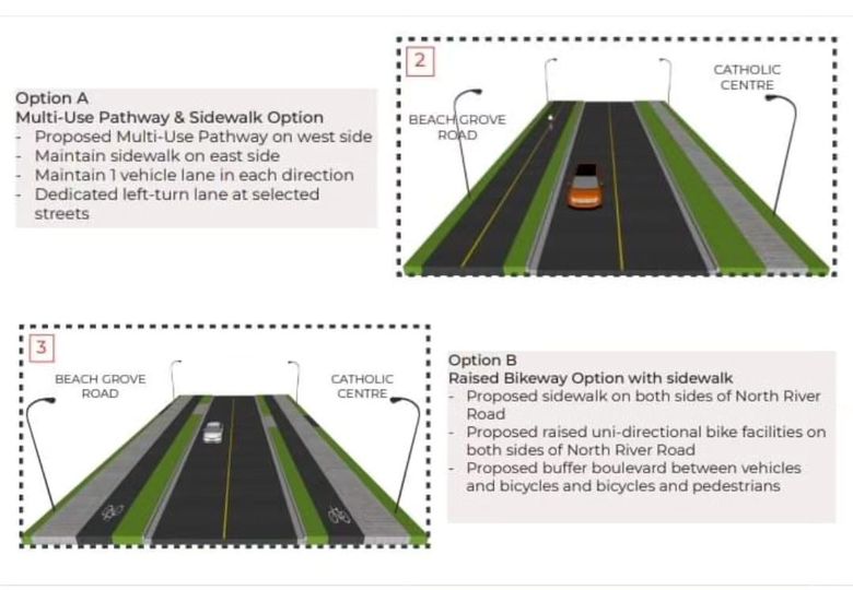
At this moment, in Charlottetown, the public is being consulted on whether the proposed new Multi-Use Pathway on North River Road (exciting!) will be bidirectional or unidirectional. Public consultation is a supported process that SAFE engages in and encourages the City of Summerside to as well. This is the graphic of the public consultation:

bidirectional or unidirectional

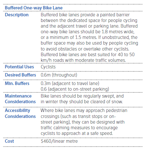
SAFE RESPONSE RE: PEI Design Standards 

 The current PEI AT Network Plan (draft, June 2022) provides the following:

Facility Guidelines (P 14 -25):

Bidirectional

Unidirectional


These facility guidelines are consistent with key provincial national guidelines: BC AT Design Guide and Transports Quebec.  They are also aligned with the National Association of City Transportation Officials (NACTO).  They are also the same guidelines that the City of Summerside included in their 2007 and in their 2012 draft Active Transporation Plans.  We say this to illustrate how long these exact guidelines have been in place.

General Network Guidelines (Page 26-32):

The General Network Guidelines list the following items:

  • Integrate principles of accessibility throughout design (Jurisdiction: Municipal & Provincial)
  • Retrofit oblique intersections (Jurisdiction: Municipal & Provincial)
  • Accommodate active transportation users in roundabout design (Jurisdiction: Municipal & Provincial)
  • Create clear path of travel on sidewalks (Jurisdiction: Municipal & Provincial)
  • Implement accessible pedestrian signals at crosswalks (Jurisdiction: Municipal & Provincial)
  • Reduce wait times at signalized crosswalks (Jurisdiction: Municipal & Provincial)
  • Widen shoulders at blind crests and curves, and on steep slopes (Jurisdiction: Municipal & Provincial)
  • Extend sidewalks and paths in priority locations (Jurisdiction: Municipal)
  • Establish traffic calming in priority locations (Jurisdiction: Municipal & Provincial)
  • Remove or repair obstacles along active transportation routes (Jurisdiction: Municipal & Provincial)
  • Encourage walkable communities (Jurisdiction: Municipal & Provincial)
  • Create safe connections between facility types (Jurisdiction: Municipal & Provincial)
  • Review allowable uses along the Confederation Trail (Jurisdiction: Provincial)
  • Expand transit service (Jurisdiction: Municipal & Provincial)
  • Explore opportunities to pave sections of the Confederation Trail (Jurisdiction: Municipal & Provincial)
  • Create safe trail crossings (Jurisdiction: Municipal & Provincial)
  • Improve safety along the Island Walk route (Jurisdiction: Provincial)

The bottom line is the exact standard that tells the Municipality when to use a bidirectional/unidirectional is not currently in the draft PEI AT Network Plan.   The same can be said about guidelines on what determines a protected AT Pathway vs a non-protected paint and a shoulder; it is a combination of traffic, collision data, vulnerable populations, close to schools, existing space, appurtenances, etc.   Essentially, it is Municipal jurisdiction to determine these items for themselves. 

===END OF SAFE NOTES==== 

ATV using the Confederation Trail (27:00)

Every year, the Province asks the City whether the City wants the gates open or closed for the winter months.  Essentially, open means the trails would be accessible to snowmobiles; closed and the gates are not accessible. The gates are not accessible in the winter for snowmobiles.  The issue was with ATVs looking to assess the Trail.  If the City is approached, they will meet with them and discuss.

Mayor's Task Force on Attainable Housing (2:34:00)

An important and historical work for the City of Summerside. 

Summerside Housing Facts

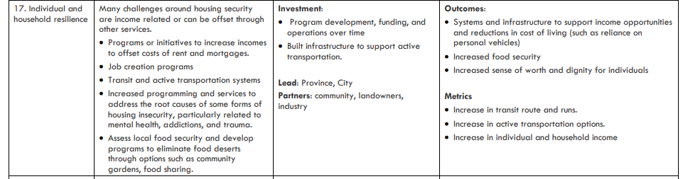
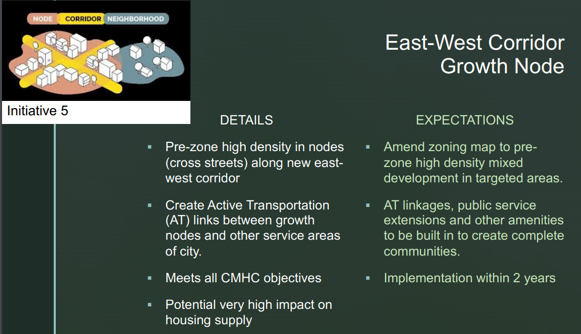
For the purposes of active transportation, AT was referenced in Program & Services Solutions (#17):

Mayor's Task Force on Attainable Housing

AT is also included in the East-West Corridor Growth Node as part of the HAF funding application:

East West Housing


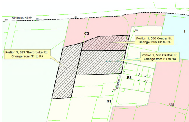
November 20,  2023: Planning Board, COW, Special Council Meeting
Additional Info: Information Package & Meeting Video --> [Minutes]

Planning Board Meeting

530 Central St & 383 Sherbrooke Rd (Official Plan & Zoning Amendments) re: Enterprise Venture Group Inc.'s application

Central Street

Impacts from the development on pedestrian/vehicular access and safety, and on public safety generally
Staff Comment: Accesses for the subject properties will need to be from Central Street; the access must be a minimum of 80m from the south edge of Sherbrooke Rd to reduce conflict point of vehicles entering right turn lane on to Central Street from Sherbrooke Rd. Currently, there is no pedestrian access along this section of Central Street. The closest sidewalk stops at the intersection of Walker Ave. and Central St. The storm system along this area is open ditch and would need to be infilled and a storm system installed to accommodate a sidewalk  installation. Council unanimously approved this amendment at the Dec 5 Committee of the Whole.    [SAFE Notes] Our Proposed Unidirectional Pathway from Sherbrooke Road up through Central would alleviate these concerns. Planning Board voted in favour and moved item to next meeting (COW) for vote.
 
Monthly Council Meeting
 
Immigrant Summerside Presentation (IRSA)
 
Enhanced Culvert Connect Program Policy Approved receives unanimous support.
 
Mayor's Task Force on Attainable Housing receives unanimous support.
 
Finance Report: The preparation of our 2024-25 capital and operating budgets will soon begin and the schedule will be provided once it has been confirmed. We are seeking input on our proposed budget and are inviting residents, businesses and stakeholders to provide comments on what they would like to see reflected in the upcoming budget. Feedback is being accepted until 12:00pm AST on Friday, December 15th, 2023. Please see our website for a form to submit your input.  Hard copy written submissions can be mailed or dropped off to City Hall, 275 Fitzroy St C1N 1H9 to the attention of Kristen Dunsford. [SAFE Notes] Not able to locate the link on the website. On Dec 8, we asked City Staff for the link—no response as of today.
 
Municipal Services 
  • A new stop sign was added on Jason and Tanton, replacing the old yield sign. Now, this is a three-way stop intersection.
  • Confirmed Pedestrian timing at Granville & Ryan intersection

Police Services

 The new traffic section has been up and running for ten months. Comparing stats from 2023 to 2022 for the same time frame:
- In 2022, there were 756 tickets issued plus 116 written warnings.
- In 2023, with the traffic unit in place, there was 1593 tickets issued plus 627 written warnings


November 29, 2024: Legislative Assembly of PEI: Motion 77: Keeping ATVs off the Confederation Trail (page 2460-2470).

Visit this video link to listen to the full debate (at the 2:11:25 mark until the 2:58 mark)

Quote from Robert Henderson (O'Leary-Inverness): 

I know some members have said, “Where did this issue come from?” Well, I can tell you where it came from. It came from an election campaign recently. I remember all the candidates were eventually invited out to the ATV Club in the Member from Alberton-Bloomfield’s riding. I went one night, and they had a lot of stuff there, a lot of ATVs. But when the Conservative candidate happened to go out there, he came with the Premier. 

They rode in on their ATV, and although I can’t say I know exactly what was said since I was not there, they certainly gave an indication they were going to review this Confederation Trail issue. I think it's where it’s all come from. I have to admit, they seemed to have a lot of that candidate’s signs up after that particular meeting. (page 2469)

All Legislative Assembly Members present supported the Motion to Keep ATVs off the Confederation Trail, including five out of six MLAs for Summerside and Area: Matt MacFarlane, Matthew MacKay, Tyler DesRoches, Hilton MacLennan, and Gilles Arsenault). Barb Ramsay was not in attendance at this meeting.

Only one Member, Hal Perry (Leader of the Official Opposition), did not support the Motion.  

Motion carried.

[SAFE Notes: SAFE Summerside submitted a 15-page letter of recommendations as part of the PEI Government Confederation Trail Public Consultation process.  SAFE Summerside did not support ATVs on the Confederation Trail.

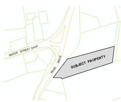
December 5,  2023: Committee of the Whole, Special Council Meeting
Additional Info: Information Package & Meeting Video  [ Minutes  ]

Committee of the Whole

Councillor Rick Morrison stated concerns with the Granville Intersection (Tim Horton's/Wendy's and Sobeys) as it does not have turning arrows, is in need of upgrades, etc.  A discussion on previous issues on this intersection.  The overall conversation highlighted the land is private property and DM Cory Snow stating that "We have done lots of things without owning the land, and it should have been done when improving the traffic." Council supported passing the issue to Planning Board Committee to review, and consider pedestrian traffic.  Councillor Morrison referenced SAFE Summeside as having concerns with this intersection.   

Special Council Meeting

The City of Summerside has received an application from 102454 PEI Inc. (Nathan Kember) for a portion of PID #756825 to amend the City Zoning Bylaw from Service Commercial (C2) zone to High Density Residential (R4) zone. The purpose of the zoning amendment is to allow high density housing (ie. row house, town house, apartment building) in the proposed R4 zone. 

Proposed Official Plan Amendment:  Change the land use from Commercial land use to Residential land use 

Proposed Zoning Bylaw Amendment:  Change the zoning from Service Commercial (C2) zone to High Density Residential (R4) zone

Reads Corner

Mr. Kember expressed the province is "rumbling" about a roundabout at this intersection, and this property would make the Read's Corner intersection a four-way intersection.


December 7, 2023: SAFE provided our official response to City of Summerside in two documents:

  1. SAFE Summerside Official Response
  2. An Active Transportation Retrofit of Intersections that Pose a Risk to AT Users

December 18,  2023: Planning Board, Monthly, & Public Emergency Shelter Meeting
Additional Info: Information Package & Meeting Video 

Monthly Council Meeting

Emergency Shelter 25 Frank Mellish Drive  - First Reading

Finance
City departments are preparing their capital and operating budgets for our 2024-25 fiscal year. These budgets will be reviewed by administration and a draft budget will be presented to council in early February. The deadline for the public to provide feedback on our upcoming budget has been extended to 12:00pm AST on Monday, January 15th, 2024. We expect to present this budget to our residents in early March 2024.


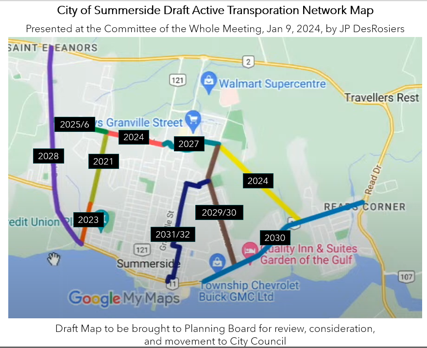
January 9, 2024: Planning Board, Committee of the Whole, Special Council Meeting
Additional Info: Information Package & Meeting Video [Minutes]

Committee of the Whole

East-West Housing Corridor Update (Councillor Adams)
Nov 14 was the original start date, followed by a Dec 11 being the start date.  No work has begun as of yet, but some measurements have been completed.  (1:24 mark)

Draft Active Transportation Network (JP DesRosiers) (1:34:40 mark)

Update (copied from slides):

  • Plan is in initial draft form
  • Staff have taken feedback from SAFE Summerside and previous internal planning for key AT routes for the following 8 years (original 10 year plan)
  • Design standards will be completed by 3rd party engineers and done so by specific route
  • The network will consider alterations as communities, neighbourhoods change and future developments occur
  • There may or will likely be alterations to timelines based on funding availability and budget pressures
  • Will there be additional considerations for routes beyond the 10 year plan? We hope!

From Map: (1:36:00)

  1. 2021 Greenwood Drive (Pope to Willow Ave)
  2. 2023 Greenwood Drive (Willow Ave to Water)
  3. 2024 Pope Road (Greenwood to Central)
  4. 2024 New East-West Housing Corridor (ongoing with AT lanes)
  5. 2025/26 Pope Road (Greenwood to South)
  6. 2027: Pope Road Ext to MacEwen Road
  7. 2028: South Drive (Highway to Greenwood Drive)
  8. 2029/30: MacEwen Road (Ryan to Water Street)
  9. 2030: Water Street East (Baywalk to Read's Corner)
  10. 2031/32: Eustane/Hanover/Lefurgey

City of Summerside Draft AT Network Map

Questions (1:39 mark)

Councillor Norma McColeman asked about budget projections.  D-CAO Desrosiers stated no budget projections have been provided.

Councillor Cory Snow asked how have SAFE responded to this plan. JP Desrosiers stated he is not sure yet as he has not followed up with SAFE yet on the City of Summerside's above draft plan.  He stated he wanted to bring it to Council first, stating they did include a number of routes that SAFE have identified and that the SAFE Summerside plan is more "robust with a significant amount of more routes identified" -- "that beyond the next 8-10 years there could be more routes that we can incorporate, but planning beyond 2032, knowing how fast our community is changing, might be an exercise in futility.  I think right now the next 8 years being mapped is a pretty good start." 

Councillor Nick Cameron discussed the importance of connecting AT lanes to destinations that people use AT to travel to, such as grocery stores, discussing that active transportation is more than exercise or recreation, "it is for people who only have a bike to ride around to get to places." D-CAO Desrosiers explained there would be "helpful tips" on how to navigate to Walmart or other places without AT routes.  D-CAO Desrosiers also communicated that "there is not a really good financially feasible method to get to north of Granville commercial district, unfortunately, and I don't want that to hinder all the other good routes we want to accomplish now....So, Gallant Street is a great option once you get off the Pope Road Extension to get down behind the grocery stores, so that will be a helpful tip amongst our promotion." 

Councillor Justin Dorion asked if the new East-West Corridor budget contains AT or if it would come out of the AT budget line.  D-CAO Desrosiers said it would be determined at budget time.  

Mayor Kutcher also stated, "it would be nice to explore what Councillor Cameron stated to connect to high-value designations, whether it be schools or grocery stores can be easily connected, a map to illustrate how the routes connect to destinations, also to schools, would be important.

The next step is to "put more meat on the bones on the first slide" to add targets and parameters and bring the draft active transportation network plan to the Planning Board for further consideration, review, and send to the Council.


January 15, 2024: Monthly Council Meeting
Additional Info: Information Package & Meeting Video [Minutes]

Emergency Shelter (8 pm to 8 am) - 25 Frank Mellish - Restricted Use Application
Cory Snow made a motion to table the discussion to the next meeting, and Bruce MacDougall seconded the motion.

In Support of Tabling the Discussion: Councillors Cory Snow, Bruce MacDougall, Carrie Adams, and Norma McColeman

As Oppossed to Tabling the Discussion: Councillors Rick Morrison, Justin Doiron, Barb Gallant, and Nick Cameron.

Mayor Dan Kuther broke the tie and voted to continue the discussion. Discussion on amendments on the application in lieu of not being presented with a site plan, etc. from the Province on the Emergency Shelter. Vote of 6-2 approved with Deputy Mayor Cory Snow and Bruce MacDoughall voted not in favour.

Finance
The preparation of our 2024-25 capital and operating budgets is well underway and council will begin their deliberations in early February. We expect to present this budget to our businesses, non-profit organizations and residents on Tuesday, March 12 at 12:00pm and vote on the budget on Wednesday, March 27 at 12:00pm. 


February 20, 2024: Monthly Council Meeting
Additional Info: Information Package & Meeting Video 

Finance
Preliminary financial results for our fiscal year ending March 31, 2024, are projecting a small consolidated surplus of approximately $104,900; this compares to our budgeted surplus of $5,300. We continue to review our projection with the individual departments and updating as required. 

The preparation of our 2024-25 capital and operating budgets is well underway and council has begun their deliberations with several meetings scheduled during the month of February. We expect to present this budget to our businesses, non-profit organizations and residents on Tuesday, March 12 at 12:00pm and vote on the budget on Wednesday, March 27 at 12:00pm

Technical Services 
Staff will create a City map showing the locations of projects planned for this upcoming year. They will add this information to our City website and continue to update it as projects proceed throughout the season.


March 5, 2024: Committee of the Whole & Special Council Meeting
Additional Info: Information Package & Meeting Video 

Committee of the Whole

East West Housing Corridor
Councillor Carrie Adams asked about a start date for this project.  No date was provided.

Snow Removal (alternating the order of which roads are done)
Topic introduced by Councillor Rick Morrison. City Staff maintain "old" Summerside and "new" Summerside (Wilmot and St. Eleanors) is maintained by private contractors. Councillor Carrie Adams asked about GPS on the snow removal equipment.

Special Council 

109 Small Ave Rezoning for Apartment Building
At the corner of Small Ave and the Confederation Trail, a proposal for a zoning amendment from an R3 to an R4 zone in order to accommodate an 8-unit apartment building was brought to Council. An image of the location can be seen as follows, which is adjacent to the Confederation Trail:

Small Ave

Councillor Carrie Adams stated (1:28:25) that "Small Ave. is without a doubt the road I get the most calls and concerns about when it comes to pedestrian safety, when it comes to speeding, when it comes to vehicles running stop signs at Flamingo and Small." City Staff to present Report to the Planning Board on March 13.  On March 13 [Meeting Package], the rezoning application motion was tied 2-2 (for: Justin Doiron and Rick Morrison; against: Mayor Dan Kutcher and DM Cory Snow), and thus a tie is considered support by the Planning Board [video], and it will go before Council at the next Council Meeting. At the March 18, 2024, Council Meeting a vote occurred on this rezoning, Councillor Carrie Adams stated (38:10), "I don't know what more I can say, other than the issues I've stated before. Safety is the main issue. There is no sidewalk, poor shoulder, no road markings, no playground in the immediate area." Other Councillors talked about their reasons for not supporting this rezoning (38:10 to the 48:41 mark).  All Councillors voted against this resolution.


March 12, 2024: Budget Speech
Additional Info: Information Package & Meeting Video  [Minutes]

The budget is presented and open for public comment for 14 days. The budget received a unanimous vote on March 27 by Council.

The budget can be viewed here.

Types of Captial Projects include

$5.5 million for the second part of phase 1 of the east west connector.
$2.14 million to complete the first building at the Summerside Business Commons ($784,000 from other levels of government)
$531,000 for street resurfacing
$530,000 for new sidewalks (MacDougall Drive and a small section on Ottawa Street to connect the new daycare) and replacement of some current sidewalks (section on Read Drive Civic #420 and Granville Street from Rogers Ave to Schurman Ave.) 
$472,000 for structure repairs to City Hall
$453,000 for active transportation infrastructure  (Pope Road from Greenwood Drive to Central Street, cost-shared 50/50, so the province also providing $453,000)
$354,000 for intersection improvements (includes signalled Greenwood Drive/Pope Road intersection and a crosswalk at Schooner/Water Street East)
$290,000 for downtown infrastructure
$277,000 for fire and police equipment
$186,500 for public works equipment
$90,000 towards ditch infilling cost share program

SAFE Summerside was awarded $2,500.

SAFE emailed the City on March 13 to request detailed information on the AT infrastructure, sidewalks, and intersection improvements. Feedback from that email is included above. 


March 18, 2024:  Monthly Council Meeting
Additional Info: Information Package & Meeting Video 

Greenhouse Gas Emission Inventory Report

Summerside recently commissioned a Greenhouse Gas Emission Inventory Report. This study aims to identify comprehensively and model greenhouse gas (GHG) emissions across the city. By doing so, it lays the groundwork for a nuanced understanding of the sources and patterns of emissions, providing a foundation for informed decision-making. The study goes beyond mere analysis; it actively seeks out opportunities for GHG reduction throughout the region. By exploring and developing strategies to curtail emissions, the city is not only adapting to the challenges posed by climate change but also positioning itself as a leader in sustainable development.

At 2.7 tonnes per capita, Summerside is leading the way on GHG emissions on a per capita basis in PEI which came in at 10.0 tonnes per capita and 17.7 nationally. The City looks to further implement innovation and adaptation to drive that number lower. Given the opportunities and direct link to economic development, growth, and sustainability, Summerside is poised to further collaborate with industry to help the community reach new heights in the fight against emissions.

The city’s top three sources of community GHG emissions are
1) electricity usage in institutional / commercial / industrial buildings;
2) industrial processes and product use (refrigerant release); and
3) waste generated by the City.

Opportunities for decarbonization include; Carbon Offsets, Electrification of Heating Systems, Local Agriculture, Electrifying Municipal Fleet and Investing in Electric Vehicle Infrastructures, Waste Diversion and Residential energy reduction projects. The City looks forward to continuing to understand, adapt and mitigate ways in which we can further mitigate our emissions and grow our economy simultaneously.

SAFE requested the report from City Staff on April 4, 2024.

The City of Summerside is working on tactical execution in the following six areas.

  1. Decarbonization of the Built Environment and Technologies to address existing and new developments on commercial and residential subdivision scales. Geothermal exchange for passive heating/cooling. Green building materials (e.g., low-carbon cement), district energy for hospitals, smart electric heating for municipal buildings, microgrids, smart devices and Positive Energy Districts Development.
  2. Renewable Energy exploring options for more utility and distributed energy generation within the city Green Hydrogen HUB – Development of the full value chain, production and use of green hydrogen, Hydrogen light-duty vehicles – municipal utility fleet/public transit, refuelling infrastructure for light duty vehicles, production by freshwater/seawater electrolysis.
  3. Energy Storage – Community level and at-premise storage opportunities, including those in the heat pump space Mechanical, Flow, Chemical/electrochemical, Utility and Residential systems, and Battery component (hardware or software) production.
  4. Summerside Xchange, the city’s main accelerator and incubator program, will expand its challenge scope to include targeting advancements in both ag-tech and the built environment, areas of strategic interest for the city.
  5. Grid Modernization and Digitization – Software solutions to manage grid and distributed energy assets. Grid systems with two-way communication, expansion of net metering, EV to building (V2B) smart grid integration, smart street lighting, IoT for water treatment, AI-based energy management for municipal buildings, and “digital twin” of city energy and water systems

Summerside Police Services

Police Services will start with videos and photos to offer traffic safety tips by our officers. They will put out such messages on video or, at the very least, in written form: “Traffic Tuesdays.”

Municipal Works

"Traffic controllers programming for Ryan and Granville intersection" is noted in the Minutes.  SAFE followed up on this issue on March 19, 2024, via email, and City Staff communicated on the same day that "green arrows were coming on every cycle without the need for a vehicle to be in the turning lanes – it has been occurring for quite some time and is yet to be resolved as more instances have cropped up. Still working out the details." We thank the City for their quick response.


April 2, 2024:  Planning Board, Committee of the Whole, Special Council Meeting
Additional Info: Information Package & Meeting Video 

Committee of the Whole

Sidewalks (Asphalt vs Concrete, Councillor Carrie Adams)
Councillor Carrie Adams put this item on the Agenda as she observed in her travels asphalt being used on sidewalks and that asphalt seemed to work well (less repairs, smoother, etc.) for that particular community.  "We have our active transportation that we are investing a lot into, too, so a wider sidewalk that could incorporate both pedestrian and cycling [may be an option]." Barb Gallant also stated her desire to have a sidewalk or paved sidewalk on Gallant Street.  The decision was to elevate this discussion to the Planning Board Committee, as this Committee is set to discuss Complete Streets at the next Planning Board meeting. This is a reminder that the Planning Board members are Mayor Dan Kutcher, Deputy Mayor Cory Snow, Councillor Justin Doiron (Chair), and Councillor Rick Morrison.

Green Commute (Councillor Nick Cameron)
CAO MacFarlane stated he started this program initially when he was the director of Human Resources. As an internal program, it was internal to City Staff.  At various thresholds, staff use green commuting (walking, cycling, rollerblading, etc.) with benefits such as city-owned memberships with fitness, financial, and environmental results.  It was advertised for external community members for a period of time. It is no longer being offered to external community members. Councillor Nick Cameron stated that it takes him 4 minutes to travel to work by car and 6 minutes to get a scooter to work.  Councillor Cameron stated it makes sense to open up the "Green Commute Program" to the external community, as the incentive can increase AT participation.  CAO will take the recommendation back to Staff to provide details on how the external aspect of this program may work and bring this back to Council.  The internal Green Commute program will begin on May 1. 


April 15, 2024:  Planning Board & Monthly Council Meeting
Additional Info: Information Package & Meeting Video 

Monthly Council Meeting

Appointment to Committees
Councillor Rick Morrison replaces Council Barb Gallant on Finance


April 16, 2024: Councillor Bard Gallant charged with fraud over $5,000
Follow this link for the news story, and the following is the Public Statement by the City of Summerside: 

Summerside City Council and City Administration have been made aware that criminal charges have been laid against Councillor Barb Gallant. These charges did not arise as result of her capacity as a City Councillor.
As this is an active criminal matter that will be brought before the courts, it is inappropriate for either Council or Administration to provide any comments at this time.
Any procedural requirements under the City’s Code of Conduct bylaw will be deferred until the criminal matter has concluded, to avoid prejudicing either the defendant or the prosecution. All inquiries should be directed to the Summerside Police Department.