A safe AT Pathway corridor that connects Summerside and Area has been a need identified as far back as 2005, based on feedback from the local cycling club at the time. There continues to be a need today based on the input from residents in these communities via SAFE’s membership form.
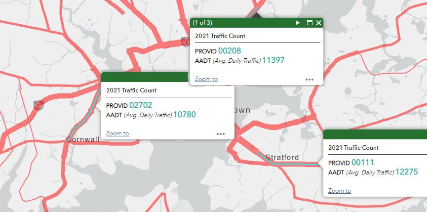
We are happy a safe and connected corridor has been created in Charlottetown – Cornwall – Stratford – East Royalty. It is proof of a commitment to AT, and this is an Island solution.
The traffic to/from Charlottetown is “on par” with traffic in Summerside.
|
To/From Charlottetown from Connector |
Traffic Count |
To/From Summerside from Connector |
Traffic Count |
|
Cornwall |
10,780 |
Kensington |
10,338 |
|
Stratford |
12,275 |
Miscouche |
11,166 |
|
East Royalty |
11,397 |
Reads Corner* |
13,867 |
|
Charlottetown By-Pass |
22,665 |
Rte 2 (to Granville Street) | 13,158 |
| North Bedeque* | 8,062 | ||
|
Bedeque* |
7,169 |
||
| Linkletter Beach* | 3,249 |
This 2021 data is derived from the PEI Government website (https://tinyurl.com/PEITraffic) . Of course, the Charlottetown by-pass has double the traffic, but the other connectors (that contain an AT Pathway) represent nearly identical traffic volume and safety challenges for the AT community:
- Cornwall (10,780) and Kensington (10,338)
- Stratford (12,275) and Miscouche (11,166)
- East Royalty (11,397) and Reads Corner (13,867)
We will provide two images we replicated from the PEI Government site:
Charlottetown and Area:
Summerside and Area:
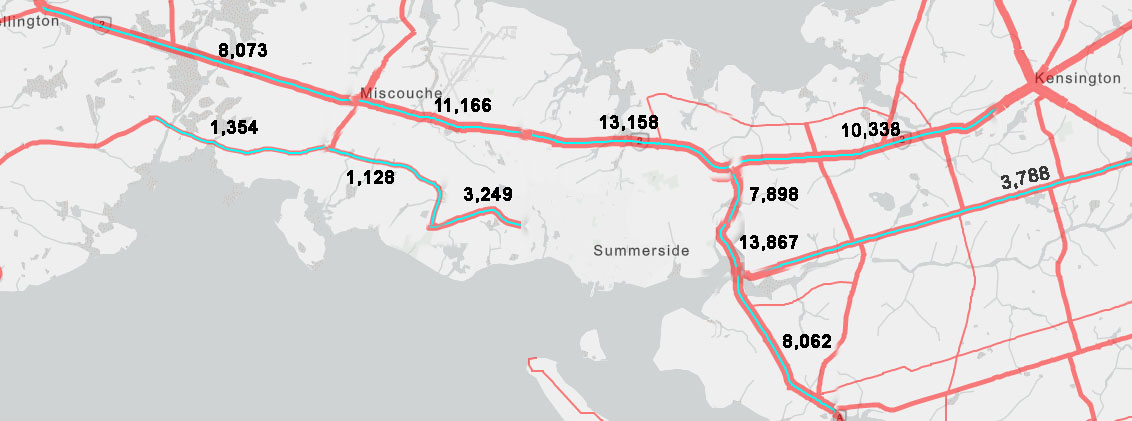
We hope that by reviewing these images and their respective traffic counts, you will come to the same conclusion that we did: if the motor vehicle traffic in Charlottetown requires a separated AT pathway to protect all the traveling public, so does all the traffic entering / leaving Summerside.
Consideration #1: We understand the Confederation Trail does provide a connection to the Miscouche - Summerside - Kensington communities. However, the Trail has several limitations (no lighting, not as intuitive as the highway, and because it is out of the public view, many potential users fear the risk of harassment/abuse). Further, the trail is used by snowmobiles in the winter months and is thus inaccessible year-round.
Our members identified the fear of harassment/abuse if participating alone in AT as a barrier to AT participation. The most significant barrier was safety (fear of motorists/personal injury). This safe corridor would eliminate such barriers and provide the necessary infrastructure to support AT to/from these neighbouring communities. Commuters travel this stretch between Kensington and Miscouche on Route 2 daily.
Consideration #2 The Bedeque / Linkletter sections are a part of the Island Walk Route; thus, the need to protect the citizens who walk along the highway with little or no shoulder needs to be taken as a priority. The province is actively promoting the Island Walk, but the province must also actively protect the citizens who are using the Island Walk.
Some of SAFE actions to date:
- Letter to Director of Capital Projects (Oct 31, 2022)
- Letter to Local MLAs, Premier King, and Official Opposition (Nov 18, 2022)
- We met with MLAs Trish Altass and Lynne Lund (Jan 4, 2023) to discuss this issue.
- We asked this question during the 2023 Provincial Election Campaign:
Whereas the Province has partnered with local municipalities and the Government of Canada to create safe off-trail AT Pathways that connect Charlottetown, Cornwall, Stratford, and East Royalty;and Whereas the traffic on the Charlottetown corridors "mirrors" the traffic on the Summerside, Kensington, Miscouche, and North Bedeque/ Reads Corner:Cornwall (10,780) and Kensington (10,338)Stratford (12,275) and Miscouche (11,166)East Royalty (11,397) and Reads Corner (13,867);and Whereas the North Bedeque/ Reads Corner and Linkletter Beach is a part of the designated Island Walk Route in need of an increase in protection for the Island Walk users (as detailed in the PEI AT Network Plan);If Elected, Will You Support:The creation of similar AT Protected Pathways along the highway that connects Kensington, Miscouche, Linkletter Beach, and North Bedeque (up to Searletown Road)?Sources:PEI Government Traffic WebsiteSAFE Summerside Corridor Connections -
Stay Tuned for What is Next.
Here are our latest SAFE Summerside Member / Supporter priorities for Summerside and Area Connectors: